Category: News

Parent category of all content that could be considered as news (as opposed to blog)

  • 2020 Trail Building and Maintenance Trips

    2020 Trail Building and Maintenance Trips

    By Doug Borthwick 

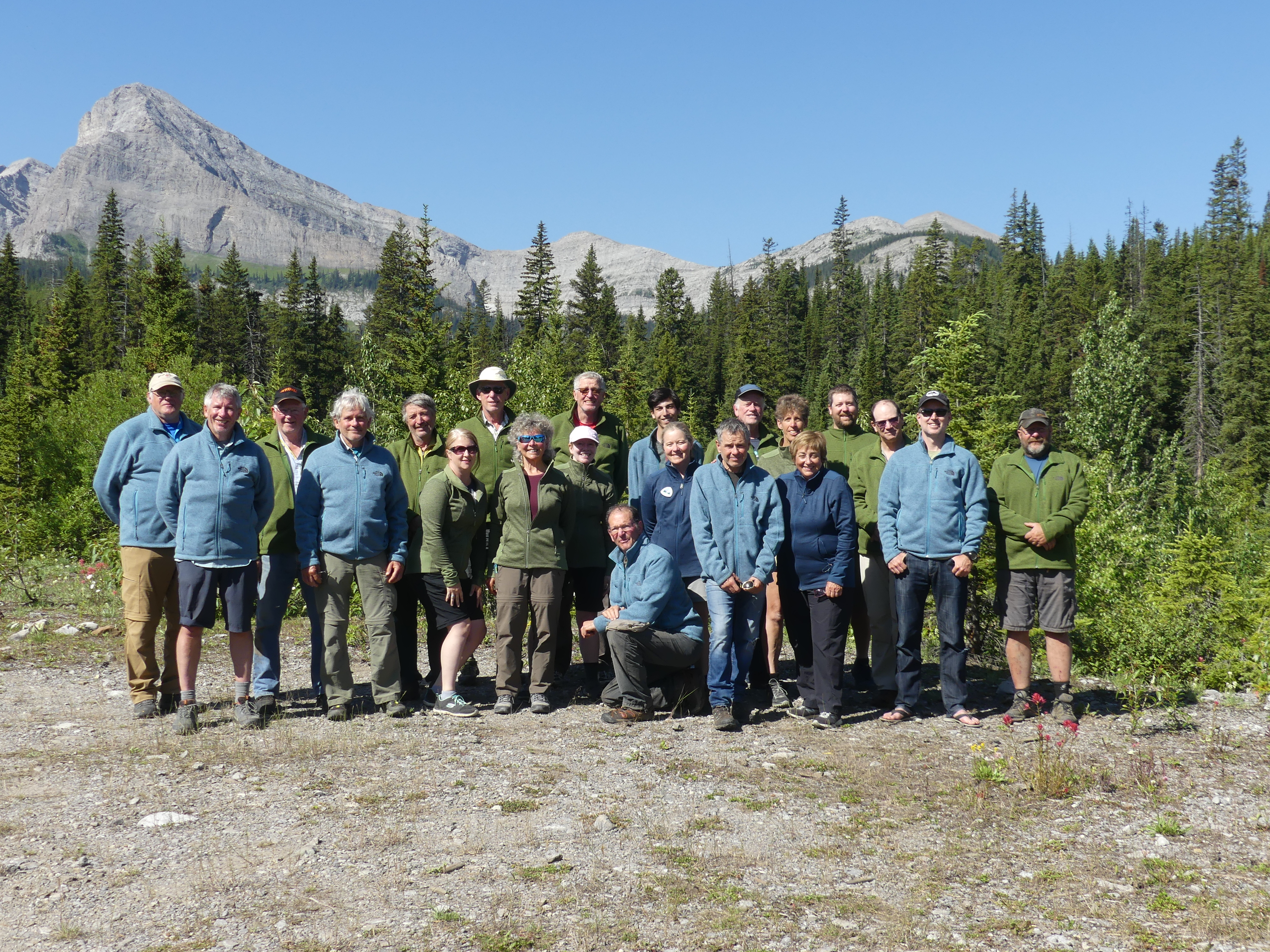
    2020 was another great year for trail building and maintenance on the Great Divide Trail.  Much thanks has to be given to all those on the GDTA Trail Building and Maintenance Committee (TMBC) who put in an extraordinary amount of work behind the scenes just to be able to safely put together any trips.  Planning was ahead of schedule and most of the planned work trips were full by February.  Then the country went into lockdown to protect citizens from a worldwide pandemic.  It was at this point that all planning was put on hold and work trips were cancelled.  There was a suggestion that all work parties for 2020 should remain cancelled.  The TBMC worked diligently to come up with a plan to safely have at least a few work parties to get a minimal amount of work and maintenance done.  After many hours of planning and strategizing they came up with a plan that would work to enable small groups to at least be able to do a little work on the GDT.  In the end, what these small work groups accomplished was amazing.  All told there were seven planned, advertised trips and two more unadvertised trips.  A total of 57 volunteers participated with many helping out on multiple work crews. 

     David Thompson Heritage Trail Trip – Cairnes and Lambe Creek Bridges:

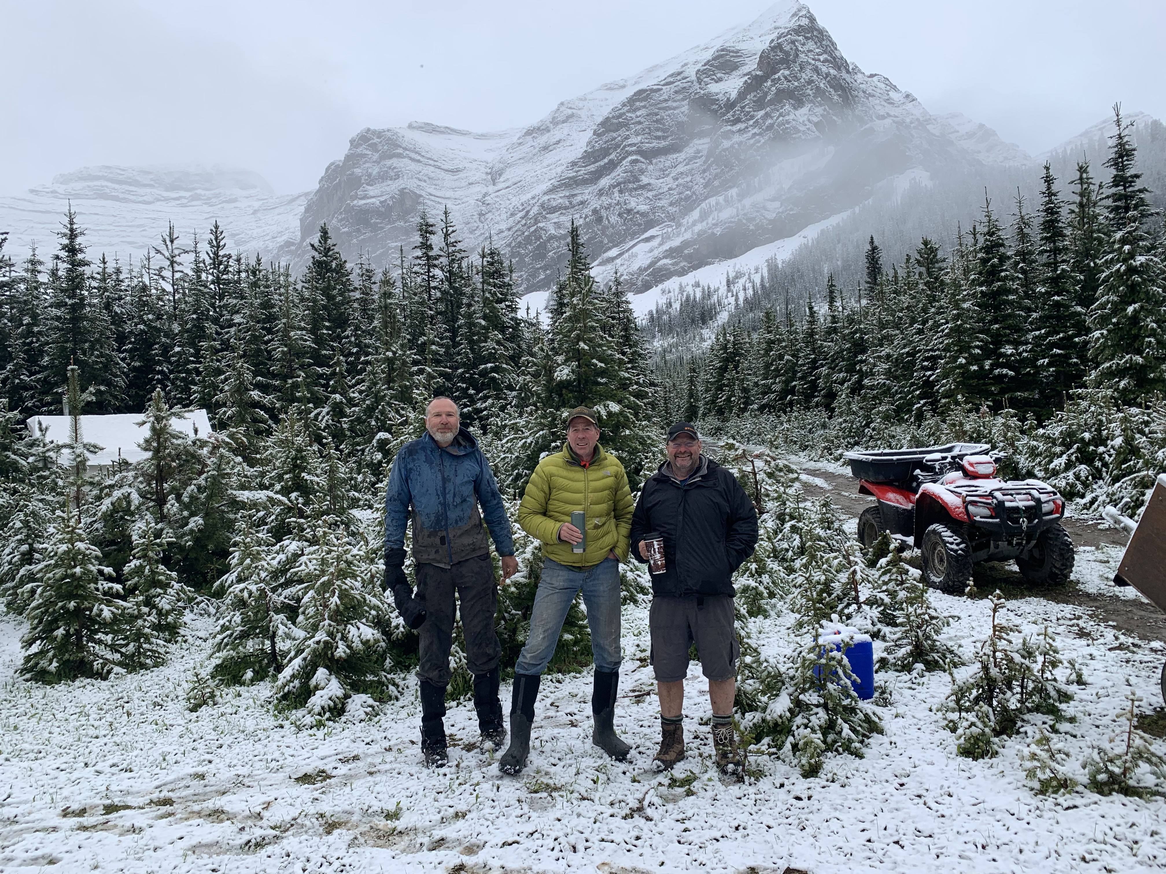
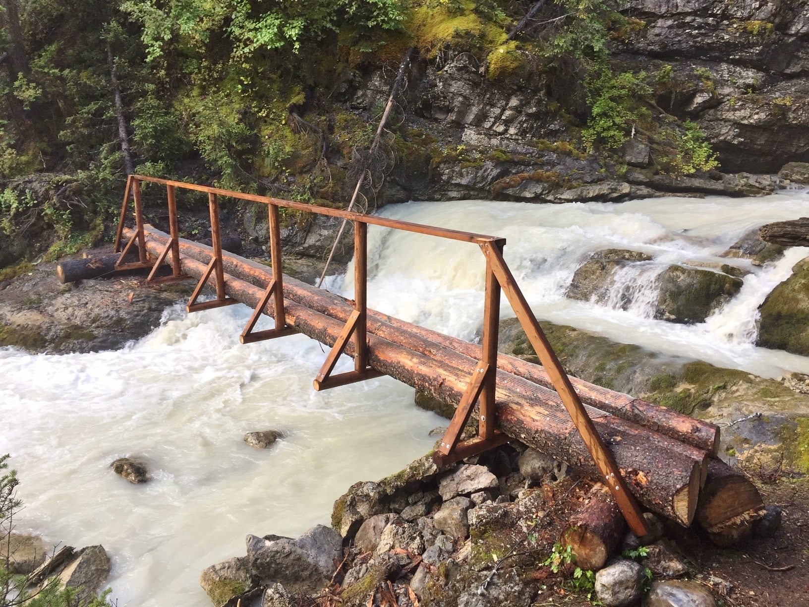
    It started in late June when a small unit of three volunteers gathered at Cairnes Creek.  The goal was to put a temporary bridge across Cairnes Creek (the double log crossing that had sufficed for the last four years had broken over the winter), rescout the first km of the David Thompson Heritage Trail (which still has flooding problems), perform a minor repair, and strengthen the new hand rail on the Lambe Creek bridge.  

    2020_trail_crew_pic_1

    The first day the crew cut the old logs and used some reclaimed lumber to make a stable crossing. 

     2020_trail_crew_pic_2

    Unfortunately two weeks later the creek flooded again and washed this temporary bridge away.  

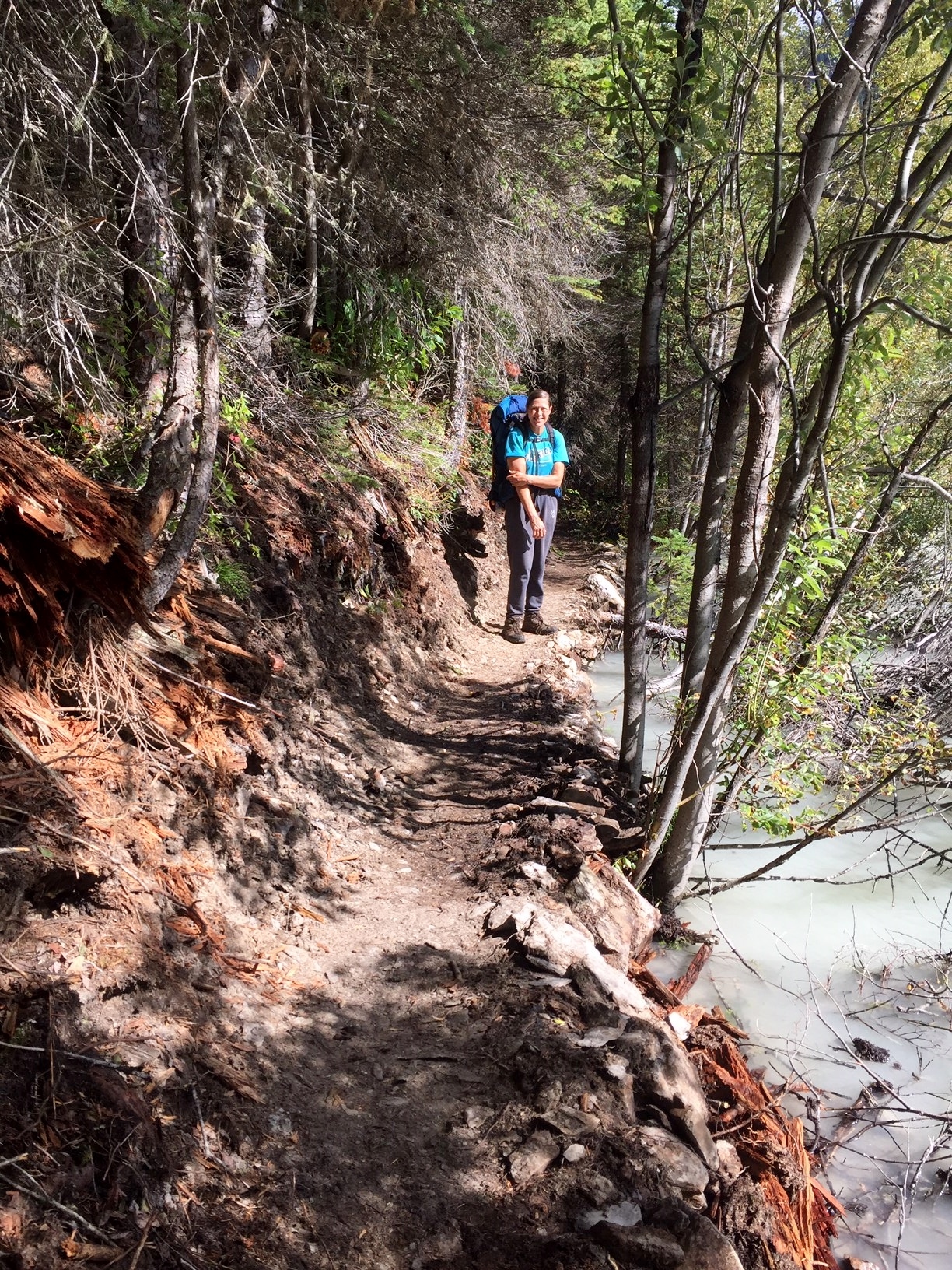
    The second day saw the crew make their way eight km up to Lambe Creek to reinforce the handrail on the Lambe Creek bridge Along the way they encountered many winter downed trees across the trail which had to be cut out They spent a few hours at Lambe Creek performing a small repair to the rail and reinforcing it with the two by fours which they had carried in by hand. 

    2020_trail_crew_pic_3

    On the walk back the crew took notes of the flooded sections still occurring in the first km for future trips. 

    High Rock Trail – Trip #1 

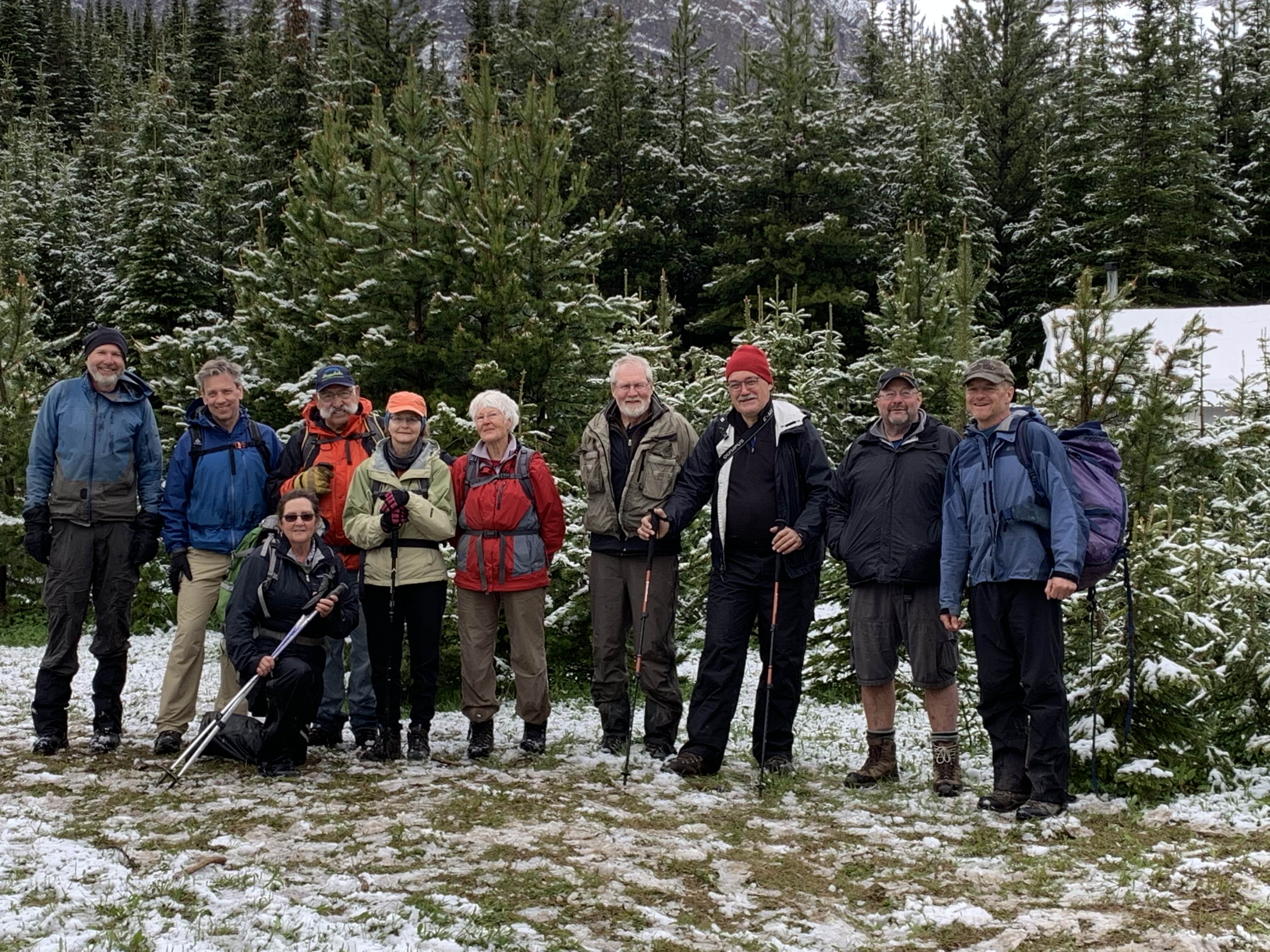
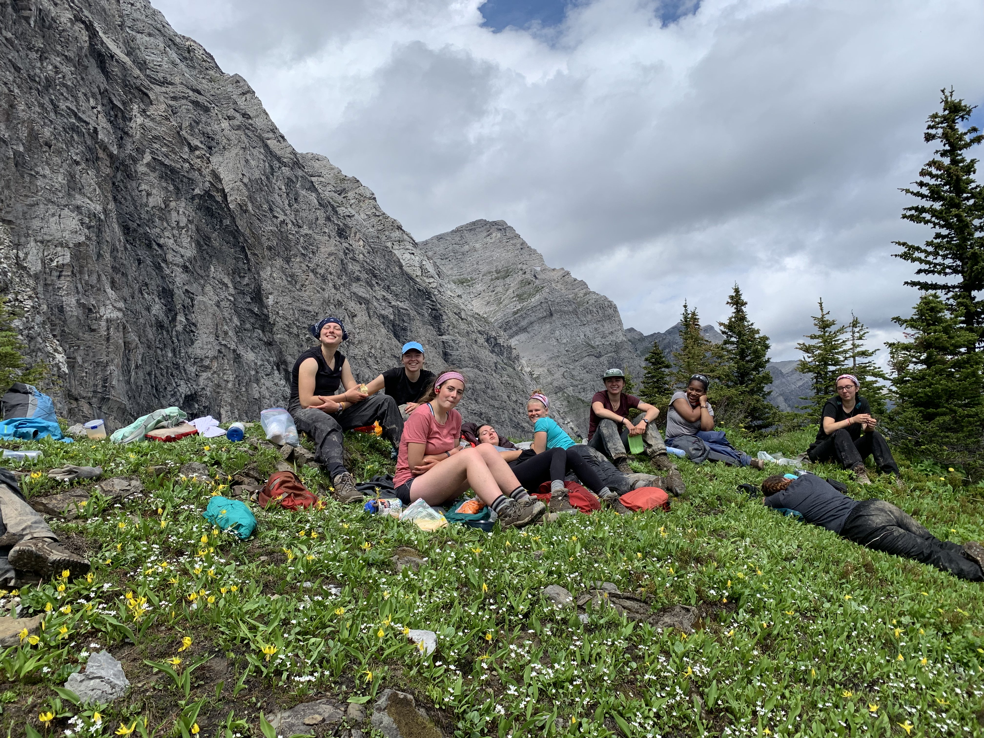
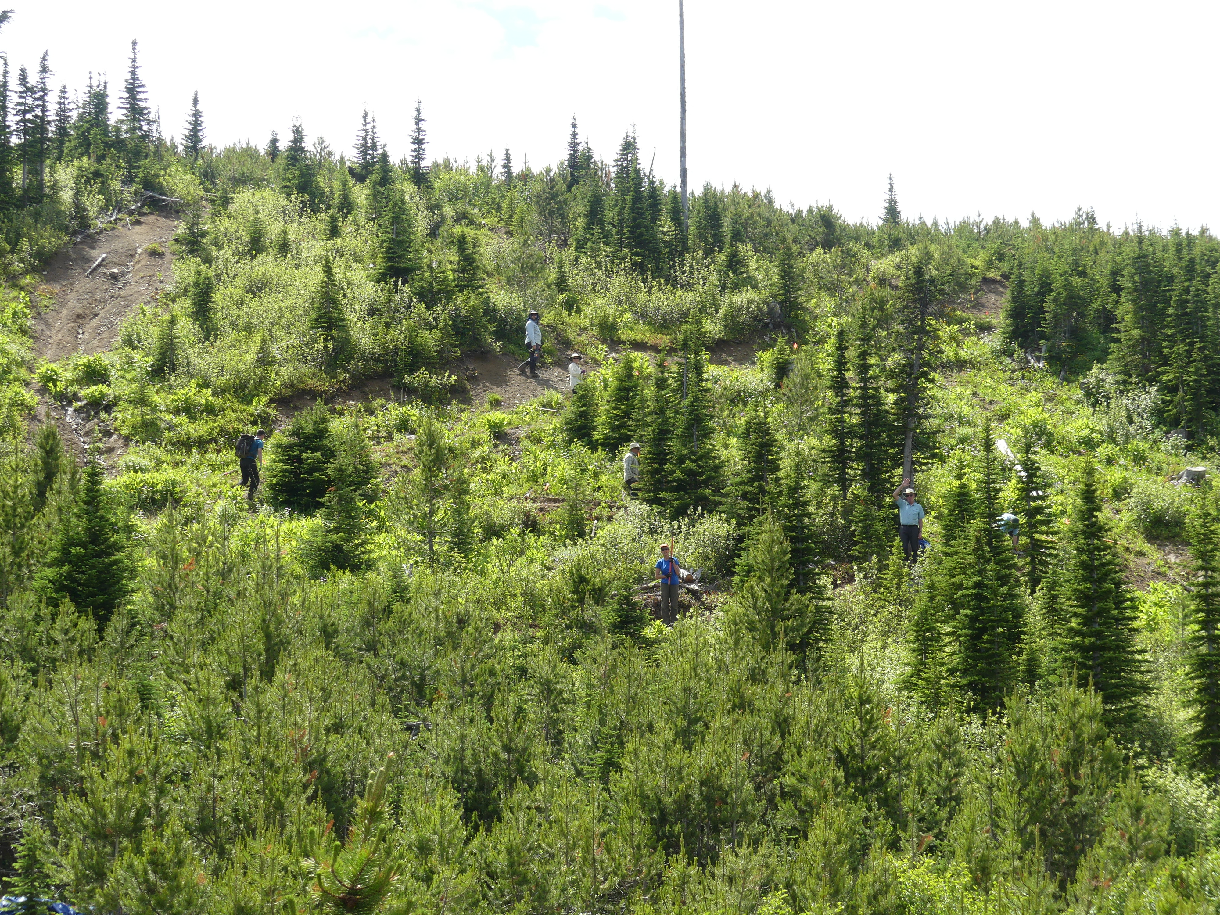
    The GDTA official trips started June 24 with a volunteer crew of eight plus another crew of eight from the Outdoor Council of Canada.  To safely have this large group, two separate camps had to be set up.  Work on section L of the High Rock Trail (HRT) was started with hopes that at the end of four work crews, 700 meters of new tread would be built.  This was all that had been cleared with chainsaws previously, and without a bird survey the crews could not chainsaw further up the ridge.  Luck would have it that in the Trip #1 crew there was a biologist who would be able to survey the trail all the way to the ridge top.  Now a chainsaw crew was able to further clear the rest of the route.  What Trip #1 crew lacked in experience, they more than made up for with great enthusiasm, and when the smoke cleared they had built an incredible 1.1 km of new trail. 

    2020_trail_crew_pic_4High Rock Trail – Trip #2 

    Trip #2 started with wet, miserable weather that would continue the whole five days.  This crew dealt with some of the most consistent wet, muddy conditions ever experienced building the HRT.  As well, they ran into some major endangered Whitebark Pine stands for which tread had to be gently built around.  Trip #2’s tough crew of six built out another incredible 400 meters of new trail. 

    2020_trail_crew_pic_5 

    High Rock Trail – Trip #3 

    The conditions were not looking too promising for the Trip #3 crew either, as they had to contend with continuing rain for the first day and a half.  Thankfully it soon cleared up and became sunny and pleasant for the remainder of their work party.  The conditions were better but the terrain proved extremely rough with steep sidehill and lots of roots and rocks to contend with.  This very experienced crew built some of the smoothest nicest tread ever, and by the end of their time they had hacked out another 400 meters of new trail. 

    2020_trail_crew_pic_6High Rock Trail – Trips #4, #5, and #6 

    Trips #4, #5, and #6 were the last scheduled ones for the HRT for 2020, and they mostly ran concurrently.  Trip #4 was camped just 1 km off the Atlas Road in section U, and with the help of a crew of Junior Forest Rangers for a day, they were able to finish tread on section U and V, and with the help of the HRT Walking Crew built a set of tricky switchbacks on section W.  As well, they built a bridge over a small creek in section U.  All in all another fantastic 1 km of tread was completed by this amazing mostly rookie crew. 

    2020_trail_crew_pic_7

    Trip #5’s crew remained camped at the start of section L, and the first day had a really tough 100 meters to complete on a super steep exposed side slope.  This was slow tedious work.  The second day things got a little easier through a fairly flat forest, and then they broke onto Hail Ridge which was easy – mostly just scratching out a route.  Meanwhile a small chainsaw crew had worked down the other side of the ridge into some new regenerated forest.  This was two days of really rough chainsaw and brusher work to get a path worked through these close growing small trees.   

    During the evening of the third night the Trip #6 Walking Crew wandered into Trip #5’s camp.  The previous three days for them had been spent marking and mapping trail from the southern start at Allison Creek.  Along the way they had built tread, met up and helped Trip #4 crew build switchbacks on section W, and cleared and marked the trail all the way.  This young enthusiastic crew of former GDT thru hikers worked two more days marking and clearing the rest of the High Rock Trail route so that there would be a possibility of making it walkable soon. 

    Large deadfall cleared by hand
    Large deadfall cleared by hand

    Meanwhile Trip #5 had crossed the ridge, and by utilizing an old horse packers trail, they were making rapid progress to the end of Section J.  The last day saw them work into the regenerated forest area where the forward chainsaw crew was still hacking away.  All in all, this incredible crew had built another 1.2 km of trail.  They did this with the help of an easy ridge and horse packers trail in the middle. 

    2020_trail_crew_pic_9So the High Rock Trips were supposedly done, resulting in an incredible 4 km of new tread built, as well as being completely cleared, marked, and mapped. 
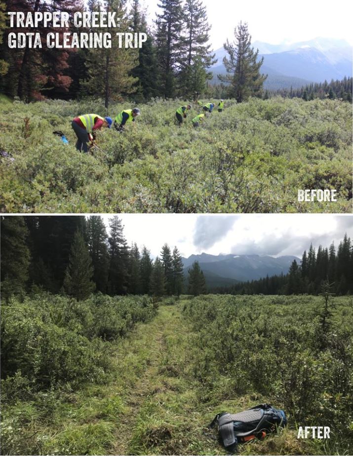
    Lost Creek Trip 

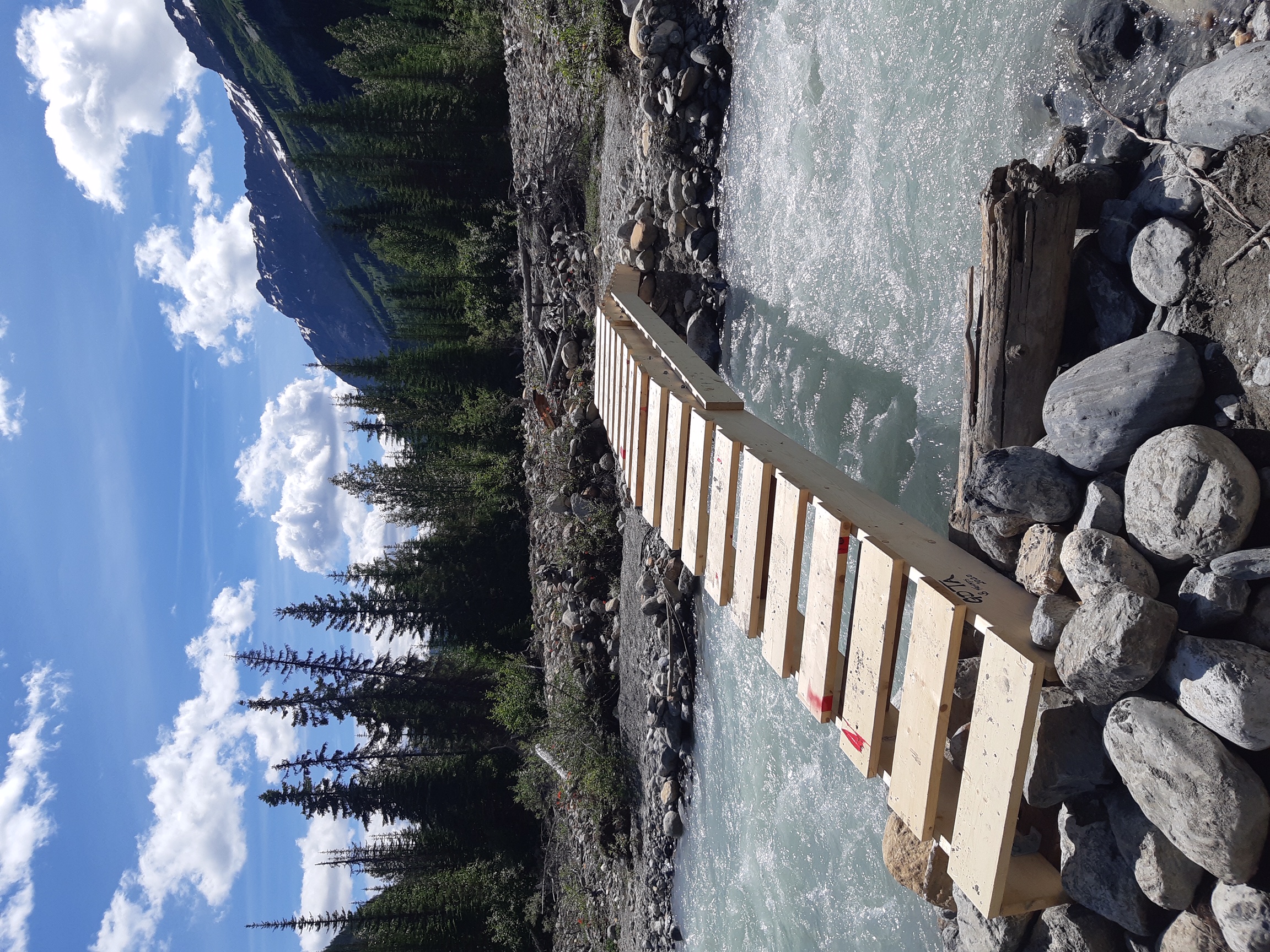
    Late July saw the largest GDTA contingent of twelve working in two teams at Lost Creek.  Team #1 worked to complete work started last year rebuilding the tread on the Lost Creek Trail.  Team #2 was tasked with building a new bridge over Lost Creek.  The weather cooperated and both teams completed their tasks to extremely high standards. 

    New Lost Creek bridge
    New Lost Creek bridge

     2020_trail_crew_pic_10b

    High Rock Trail – Trip #7 

    When the Walking Crew’s report came in, it was felt that the entire HRT was “almost Walkable”.  The only really tricky part was a 1 km section at the top of Section E which was deemed too hard to follow.  A decision was made to see if it was possible to get a last minute volunteer crew put together to take care of the impassible kilometer.  The call went out and five veterans and one rookie answered. 

    The newly made up High Rock crew was designated as Trip #7, and included five fairly experienced trail builders and one rookie.  They worked during the hottest period of the summer.  This enthusiastic crew right away had some decision making as the marked trail was confusing.  Working on some difficult side slope off the bat, they had to contend with stacking some switchbacks where none looked possible.  Slowly, for the first three days they built the new tread.  Each day had a bonus as GDT thru hikers started passing them, showing that the High Rock Trail was being utilized.  The last day was the most difficult terrain as it hadn’t been properly cleared or brushed.  Building good tread on this last bit would normally take a fairly large crew one full trip.  The issue was that this was the critical area that hikers could not follow unless there was some sort of a path.  Digging deep, the five remaining trail builders determined they could at least make something followable and semi-walkable.  What they accomplished was an extraordinary, very walkable path.  Another 1 km of tread had been built and on July 24, the new High Rock Trail officially opened for business! 

    Sunset on the GDTA basecamp
    Sunset on the GDTA basecamp

    Cairnes Creek Bridge Trip (yes, again…) 

    Meanwhile an informal crew of six or so had come together mid July to cobble together another temporary crossing of troublesome Cairnes Creek, so that this years hikers might have a safe crossing. 

    New temporary Cairnes Creek bridge
    New temporary Cairnes Creek bridge

    Late Season Scouting Trips 

    This should have been the end of the story except that there was still work to do so that preparations could be made for work in 2021.  In mid September, a small crew got together again at Cairnes Creek to survey for a new permanent bridge, come up with solutions to mitigate future flooding on the first 1 km of the DTHT, and survey the new possible future route across Amiskwi Ridge and Collie Creek on the east side of the Blaeberry River 

    Surveying for a new bridge over Cairnes Creek
    Surveying for a new bridge over Cairnes Creek

    2020_trail_crew_pic_14

    Additionally, scouting has taken place in early October for next years work on the HRT sections M, N, and O.  Lots to look forward to! 
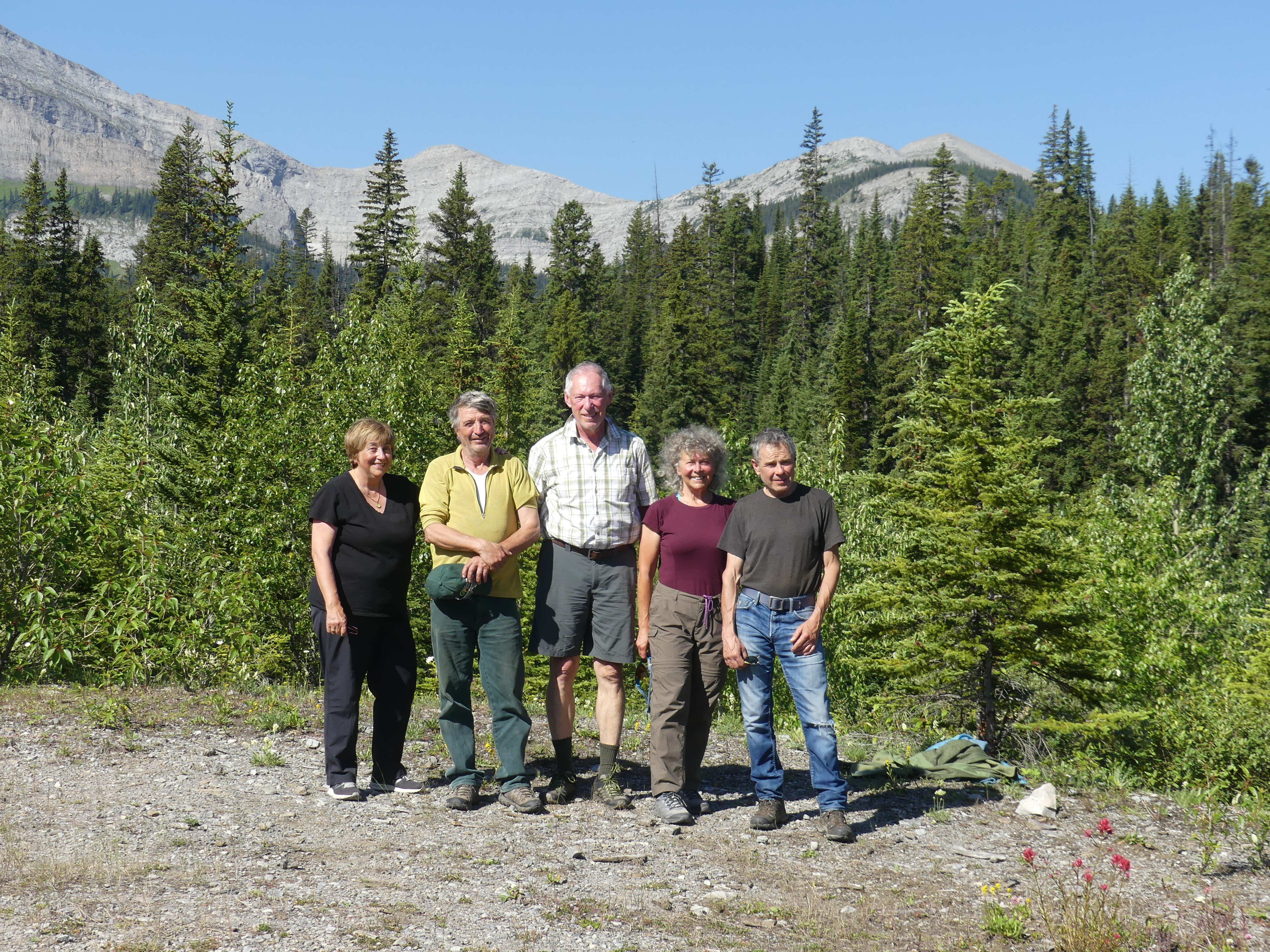
    Thank you to all 

    Many thanks to all of this years trail building crews, as well as the people behind the scenes putting everything together.  

    Thanks also go out to our sponsors and partners whose generosity has greatly enhanced our trail building and maintenance capabilities – They include Alberta Equestrian Federation, Alberta Environment and Park, BC Rec Sites and Trails, The North Face, MEC, Teck, Stihl, and Columbia Basin Trust. 

  • October 2020 Trail and Road Conditions

    October 2020 Trail and Road Conditions

    Trail Conditions Update – October 15, 2020

    Fall colours are here, and so is the snow! Snow has fallen at higher elevation on parts of the GDT so expect wet, slippery and muddy trail conditions. Boots or cleats and poles are recommended. Nighttime and early morning temperatures are below freezing, so be prepared for cold temperatures and shorter days when travelling into the backcountry this fall. 

    Due to the COVID-19 pandemic, the GDTA supports single-day hikes or horseback rides on the GDT and longer (weekend or multi-day), self-sufficient trips that don’t require resupply, where trails and trailheads are open. Please observe 2-metre physical distancing at all times on the GDT and avoid long-distance ‘thru’ hikes that involve resupplying and interaction with people in communities along the GDT. To limit the potential transmission of the virus between you and others, being completely self-supported on GDT outings is essential. Stay local, bring everything you need, avoid side trips from the trail to resupply, and always Leave No Trace.

    CLOSURES:

    • Numa Creek Trail (Rockwall access trail) remains closed due to the bridge out over the Vermilion River. The pedestrian bridge is being replaced this summer and access to the Rockwall from this location will be restored later this year.
    • Trail 7 near Jasper is closed to hikers south of the junction with Trail 7e and north of the junction with Trail 7a due to grizzly and black bears frequenting the area. Detour by taking Trail 4g to Edith Lake from where there are a few options to reach Old Fort Point trailhead or Jasper townsite. Equestrians can still use Trail 7 but are not to dismount.

    TRAIL NOTICES:

    • BEARS: It’s pre-hibernation feeding season for both black and grizzly bears which increases the chances of running into a bear on the trail. It is easy to surprise a bear that is focussed on feeding so make noise while hiking in bear territory. Be alert, make noise, carry bear spray and if you see a bear, back away slowly and leave the area. 
    • ELK: It is elk rutting season until mid-October. Warning signs that read “ATTENTION – Elk Mating” have been posted at areas where elk herds often gather. Be aware that bull elk become extremely aggressive during rutting season so keep at least 30 metres away from all elk and never get between a male and female elk.
    • The Akamina Parkway is now open so this means the GDT has completely re-opened in Waterton Lakes National Park.
    • The new High Rock Trail is open. Check it out here.
    • Cairnes Creek (d9): A new temporary bridge was built on July 18 to replace the two fallen trees that washed away. If the bridge washes away, Cairnes Creek is glacial fed and a potentially challenging ford. It is recommended to ford the creek early in the morning when glacial melt is lowest.
    • The David Thompson Heritage Trail was cleared from Cairnes Creek to Howse Pass in 2019. A new log bridge is in place across Lambe Creek. 
    • Descending the north side of Howse Pass (d11), the main route of the GDT now follows Conway Creek and Howse River floodplains wherever possible, without crossing the main channel of the Howse River. The floodplain is wide and scenic. There are several shallow fords of smaller channels on the floodplain so hikers must be prepared to have wet feet while enjoying a significantly better hiking experience than the old overgrown trail strewn with hundreds of fallen trees. In June and early July, the Howse River may be in flood making some sections of the floodplain difficult or impassable in which case hikers should consider using the old trail (now marked as an alternate route). Conversely, in late August and September when the river is low, hikers may be able to ford the main river channel and completely avoid any bushwhacking along the river’s edge. See here for a more detailed route description.
    • The Yates Torrent Bridge is out at the crossing of the Coleman Glacier outflow (near f16). Do not attempt to cross at the old bridge location, ford the Smoky River in the floodplain. Look for cairns marking the best crossing location and attempt to cross early in the morning when glacial melt is the lowest or be prepared for a fast and potentially dangerous ford.
    • The bridges across Gendarme and Carcajou Creeks are out on the Jasper North Boundary Trail. These two creeks are smaller than the Smoky River, but can still be treacherous. Cross Gendarme at the horse crossing just below the old bridge (marked), and Carcajou about 100m below the trail.
    • The ford of Buchanan Creek on the trail to Kakwa Lake can be hazardous after heavy rains. Look to cross upstream where the creek is wider and shallow.

    ACCESS ROADS: 

    • In Waterton Lakes National Park, the Akamina Parkway is open for hiking and biking, and opened to vehicles on October 1, 2020.
    • For more information, check out Alberta 511 and Drive BC.

    National and Provincial Park Trail Conditions:

    Banff National Park
    Jasper National Park
    Kootenay National Park
    Waterton Lakes National Park
    Yoho National Park

    Akamina‐Kishinena Provincial Park
    Castle Wildland Provincial Park
    Castle Provincial Park
    Elk Lakes Provincial Park
    Height of the Rockies Provincial Park
    Kakwa Provincial Park
    Mount Assiniboine Provincial Park
    Mount Robson Provincial Park
    Peter Lougheed Provincial Park

  • September 2020 Trail and Road Conditions

    September 2020 Trail and Road Conditions

    Trail Conditions Update – September 21, 2020

    While Alberta and British Columbia continue to cautiously move into the next phases of living with COVID-19, the Great Divide Trail Association has considered what is best for the health and safety of the trail community that we serve. Staying active in the outdoors is an excellent way to keep your body and mind healthy but we need to continue to do our part to limit the spread of COVID-19.

    At this time, the GDTA supports single-day hikes or horseback rides on the GDT and longer (weekend or multi-day), self-sufficient trips that don’t require resupply, where trails and trailheads are open. 

    Please observe 2-metre physical distancing at all times on the GDT and avoid long-distance ‘thru’ hikes that involve resupplying and interaction with people in communities along the GDT. To limit the potential transmission of the virus between you and others, being completely self-supported on GDT outings is essential. Stay local, bring everything you need, avoid side trips from the trail to resupply, and always Leave No Trace.

    • Parks Canada re-opened all national parks along the GDT on June 1, and all GDT backcountry campgrounds in the national parks re-opened on June 22. New online reservations for backcountry campgrounds opened on June 24. Existing reservations from international visitors, including visitors from the USA, will be cancelled and automatically refunded in full up to and including October 5, 2020.
    • Alberta Parks re-opened all provincial parks on May 1. Campground reservations opened on May 14 and all Alberta backcountry campsites – both reserved and first-come, first-served – now allow 100% capacity.
    • BC Parks re-opened all provincial parks along the GDT on May 14 and most provincial backcountry campgrounds along the GDT re-opened on June 1.

    CLOSURES:

    • Numa Creek Trail (Rockwall access trail) remains closed due to the bridge out over the Vermilion River. The pedestrian bridge is being replaced this summer and access to the Rockwall from this location will be restored later this year.
    • Trail 7 near Jasper is closed to hikers south of the junction with Trail 7e and north of the junction with Trail 7a due to grizzly and black bears frequenting the area. Detour by taking Trail 4g to Edith Lake from where there are a few options to reach Old Fort Point trailhead or Jasper townsite. Equestrians can still use Trail 7 but are not to dismount.

    TRAIL NOTICES:

    Fall colours are here! Trail conditions are generally good but expect some wet and muddy sections particularly during periods of rain. Be prepared for colder temperatures and shorter days when travelling on the trail this month.

    • BEARS: It’s pre-hibernation feeding season for both black and grizzly bears which increases the chances of running into a bear on the trail. It is easy to surprise a bear that is focussed on feeding so make noise while hiking in bear territory. Be alert, make noise, carry bear spray and if you see a bear, back away slowly and leave the area. 
      • Bear warning in Waterton Lakes National Park: A black bear is frequenting the Lakeshore Trail from the townsite to Boundary Bay and has approached people attempting to get food. Special caution is recommended while camping at Boundary Bay or Berth Bay campgrounds. 
    • ELK: It is elk rutting season until mid-October. Warning signs that read “ATTENTION – Elk Mating” have been posted at areas where elk herds often gather. Be aware that bull elk become extremely aggressive during rutting season so keep at least 30 metres away from all elk and never get between a male and female elk.
    • FIRES: There is a FIRE BAN in effect in southern Alberta, covering the GDT from Sage Pass to North Kananaskis Pass. Fire advisories are in effect along most of the GDT including in all national parks. If you must have a campfire in the backcountry, ensure you follow the rules.
    • The Akamina Parkway is now open for hiking and biking, and will open to vehicles on October 1, 2020. This means the GDT has completely re-opened in Waterton Lakes National Park.
    • The new High Rock Trail is open. Check it out here.
    • The GDT is blocked by avalanche debris south of Tornado Pass (b16). Hikers can get around by traversing upslope.  
    • Cairnes Creek (d9): A new temporary bridge was built on July 18 to replace the two fallen trees that washed away. If the bridge washes away, Cairnes Creek is glacial fed and a potentially challenging ford. It is recommended to ford the creek early in the morning when glacial melt is lowest.
    • The David Thompson Heritage Trail was cleared from Cairnes Creek to Howse Pass in 2019. A new log bridge is in place across Lambe Creek. 
    • Descending the north side of Howse Pass (d11), the main route of the GDT now follows Conway Creek and Howse River floodplains wherever possible, without crossing the main channel of the Howse River. The floodplain is wide and scenic. There are several shallow fords of smaller channels on the floodplain so hikers must be prepared to have wet feet while enjoying a significantly better hiking experience than the old overgrown trail strewn with hundreds of fallen trees. In June and early July, the Howse River may be in flood making some sections of the floodplain difficult or impassable in which case hikers should consider using the old trail (now marked as an alternate route). Conversely, in late August and September when the river is low, hikers may be able to ford the main river channel and completely avoid any bushwhacking along the river’s edge. See here for a more detailed route description.
    • The Yates Torrent Bridge is out at the crossing of the Coleman Glacier outflow (near f16). Do not attempt to cross at the old bridge location, ford the Smoky River in the floodplain. Look for cairns marking the best crossing location and attempt to cross early in the morning when glacial melt is the lowest or be prepared for a fast and potentially dangerous ford.
    • The bridges across Gendarme and Carcajou Creeks are out on the Jasper North Boundary Trail. These two creeks are smaller than the Smoky River, but can still be treacherous. Cross Gendarme at the horse crossing just below the old bridge (marked), and Carcajou about 100m below the trail.
    • The ford of Buchanan Creek on the trail to Kakwa Lake can be hazardous after heavy rains. Look to cross upstream where the creek is wider and shallow.

    ACCESS ROADS: 

    • In Waterton Lakes National Park, the Akamina Parkway is now open for hiking and biking, and will open to vehicles on October 1, 2020.
    • Sunshine Road reopened on June 21 but Sunshine Village will be closed for the entire 2020 season, including the shuttle and gondola.
    • For more information, check out Alberta 511 and Drive BC.

    National and Provincial Park Trail Conditions:

    Banff National Park
    Jasper National Park
    Kootenay National Park
    Waterton Lakes National Park
    Yoho National Park

    Akamina‐Kishinena Provincial Park
    Castle Wildland Provincial Park
    Castle Provincial Park
    Elk Lakes Provincial Park
    Height of the Rockies Provincial Park
    Kakwa Provincial Park
    Mount Assiniboine Provincial Park
    Mount Robson Provincial Park
    Peter Lougheed Provincial Park

  • August 2020 Trail and Road Conditions

    August 2020 Trail and Road Conditions

    Trail Conditions Update – August 28, 2020

    While Alberta and British Columbia continue to cautiously move into the next phases of living with COVID-19, the Great Divide Trail Association is considering what is best for the health and safety of the trail community that we serve. Staying active in the outdoors is an excellent way to keep your body and mind healthy but we need to continue to do our part to limit the spread of COVID-19.

    At this time, the GDTA supports single-day hikes or horseback rides on the GDT and longer (weekend or multi-day), self-sufficient trips that don’t require resupply, where trails and trailheads are open. 

    Please observe 2-metre physical distancing at all times on the GDT and avoid long-distance ‘thru’ hikes that involve resupplying and interaction with people in communities along the GDT. To limit the potential transmission of the virus between you and others, being completely self-supported on GDT outings is essential. Stay local, bring everything you need, avoid side trips from the trail to resupply, and always Leave No Trace.

    • Parks Canada re-opened all national parks along the GDT on June 1, and all GDT backcountry campgrounds in the national parks re-opened on June 22. New online reservations for backcountry campgrounds opened on June 24. Existing reservations from international visitors, including visitors from the USA, will be cancelled and automatically refunded in full up to and including October 5, 2020.
    • Alberta Parks re-opened all provincial parks on May 1. Campground reservations opened on May 14 and all Alberta backcountry campsites – both reserved and first-come, first-served – now allow 100% capacity.
    • BC Parks re-opened all provincial parks along the GDT on May 14 and most provincial backcountry campgrounds along the GDT re-opened on June 1.

    CLOSURES:

    • Waterton Lakes National Park: The Akamina Parkway is closed to vehicles, pedestrians and bicycles due to construction resulting in no access to Cameron Lake, Akamina Pass, Rowe Lakes or the Mount Rowe Alternate Route. As long as the Akamina Parkway remains closed to hikers, a detour can be followed from Waterton Townsite to reconnect with the GDT via the Crandell Lake Trail, Red Rock Parkway and Blakiston Valley Trail, a distance of about 26 km vs 43 km on the GDT.
    • Numa Creek Trail (Rockwall access trail) remains closed due to the bridge out over the Vermilion River. The pedestrian bridge is being replaced this summer and access to the Rockwall from this location will be restored later this year.
    • Trail 7 near Jasper is closed to hikers south of the junction with Trail 7e and north of the junction with Trail 7a due to grizzly and black bears frequenting the area. Detour by taking Trail 4g to Edith Lake from where there are a few options to reach Old Fort Point trailhead or Jasper townsite. Equestrians can still use Trail 7 but are not to dismount.

    TRAIL NOTICES:

    Trail conditions are generally good but expect some wet and muddy sections particularly during periods of rain. Warm weather means rapid melt during the day resulting in high water levels and potentially dangerous creek crossings, so attempt to ford larger creeks early in the day when water levels are lowest.

    • BEARS: It’s berry season! Berry bushes border trails, roads and campgrounds on the GDT, and black and grizzly bears are feeding on berries right now. Be bear aware on the trails this summer: be alert, make noise and carry bear spray.
      • Bear warning in Waterton Lakes National Park: A black bear is frequenting the Lakeshore Trail from the townsite to Boundary Bay and has approached people attempting to get food. Special caution is advised when camping in Boundary Bay and Bertha Bay campgrounds. 
    • FIRES: There is a FIRE BAN in effect in southern Alberta, covering the GDT from the international border in Waterton Lakes National Park to North Kananaskis Pass. Fire advisories are in effect along most of the GDT including in all national parks. If you must have a campfire in the backcountry, ensure you follow the rules.
    • The new High Rock Trail is open! Check it out here.
    • The GDT is blocked by avalanche debris south of Tornado Pass (b16). Hikers can get around by traversing upslope.  
    • Cairnes Creek (d9): A new temporary bridge was built on July 18 to replace the two fallen trees that washed away. If the bridge washes away, Cairnes Creek is glacial fed and a potentially challenging ford. It is recommended to ford the creek early in the morning when glacial melt is lowest.
    • The David Thompson Heritage Trail was cleared from Cairnes Creek to Howse Pass in 2019. A new log bridge is in place across Lambe Creek. 
    • Descending the north side of Howse Pass (d11), the main route of the GDT now follows Conway Creek and Howse River floodplains wherever possible, without crossing the main channel of the Howse River. The floodplain is wide and scenic. There are several shallow fords of smaller channels on the floodplain so hikers must be prepared to have wet feet while enjoying a significantly better hiking experience than the old overgrown trail strewn with hundreds of fallen trees. In June and early July, the Howse River may be in flood making some sections of the floodplain difficult or impassable in which case hikers should consider using the old trail (now marked as an alternate route). Conversely, in late August and September when the river is low, hikers may be able to ford the main river channel and completely avoid any bushwhacking along the river’s edge. See here for a more detailed route description.
    • The Yates Torrent Bridge is out at the crossing of the Coleman Glacier outflow (near f16). Do not attempt to cross at the old bridge location. There are two options: (1) ford the Smoky River in the floodplain; or (2) ford Yates Torrent approximately 500m upstream (location was flagged in 2017). At both locations attempt to cross early in the morning when glacial melt is the lowest or be prepared for a fast and potentially dangerous creek ford.
    • The bridges across Gendarme and Carcajou Creeks are out on the Jasper North Boundary Trail. These two creeks are smaller than the Smoky River, but can still be treacherous. Cross Gendarme at the horse crossing just below the old bridge (marked), and Carcajou about 100m below the trail.

    ACCESS ROADS: 

    • In Waterton Lakes National Park, the Akamina Parkway is closed to vehicles, pedestrians and bicycles.
    • Sunshine Road reopened on June 21 but Sunshine Village will be closed for the entire 2020 season, including the shuttle and gondola.
    • The Walker Forest Service Road will have intermittent delays for repairs scheduled to be completed on the Fraser River Bridge, located at km 5.3. Work is scheduled to commence on August 17, and will last approximately 7 days.
    • For more information, check out Alberta 511 and Drive BC.

    National and Provincial Park Trail Conditions:

    Banff National Park
    Jasper National Park
    Kootenay National Park
    Waterton Lakes National Park
    Yoho National Park

    Akamina‐Kishinena Provincial Park
    Castle Wildland Provincial Park
    Castle Provincial Park
    Elk Lakes Provincial Park
    Height of the Rockies Provincial Park
    Kakwa Provincial Park
    Mount Assiniboine Provincial Park
    Mount Robson Provincial Park
    Peter Lougheed Provincial Park

  • July 2020 Trail and Road Conditions

    July 2020 Trail and Road Conditions

    Trail Conditions Update – July 27, 2020

    While Alberta and British Columbia continue to cautiously move into the next phases of living with COVID-19, the Great Divide Trail Association is considering what is best for the health and safety of the trail community that we serve. Staying active in the outdoors is an excellent way to keep your body and mind healthy but we need to continue to do our part to limit the spread of COVID-19.

    At this time, the GDTA supports single-day hikes or horseback rides on the GDT and longer (weekend or multi-day), self-sufficient trips that don’t require resupply, where trails and trailheads are open. 

    Please observe 2-metre physical distancing at all times on the GDT and avoid long-distance ‘thru’ hikes that involve resupplying and interaction with people in communities along the GDT. To limit the potential transmission of the virus between you and others, being completely self-supported on GDT outings is essential. Stay local, bring everything you need, avoid side trips from the trail to resupply, and always Leave No Trace.

    • Parks Canada re-opened all national parks along the GDT on June 1, and all GDT backcountry campgrounds in the national parks re-opened on June 22. New online reservations for backcountry campgrounds opened on June 24. All existing national park reservations prior to June 22 will be automatically cancelled and refunded in full. Existing reservations from international visitors, including visitors from the USA, will be cancelled and automatically refunded in full up to and including August 7, 2020.
    • Alberta Parks re-opened all provincial parks on May 1. Campground reservations opened on May 14 for Alberta residents only for camping dates starting June 1. All Alberta backcountry campsites – both reserved and first-come, first-served – now allow 100% capacity.
    • BC Parks re-opened all provincial parks along the GDT on May 14. Most provincial backcountry campgrounds along the GDT re-opened on June 1 for BC residents. Backcountry camping opportunities remain available for non-BC residents accessing Elk Lakes, Height of the Rockies and Mount Assiniboine provincial parks on the Alberta/BC border through existing established trail routes. 

    CLOSURES:

    • Waterton Lakes National Park: The Akamina Parkway is closed to vehicles, pedestrians and bicycles due to construction resulting in no access to Cameron Lake, Akamina Pass, Rowe Lakes or the Mount Rowe Alternate Route. As long as the Akamina Parkway remains closed to hikers, a detour can be followed from Waterton Townsite to reconnect with the GDT via the Crandell Lake Trail, Red Rock Parkway and Blakiston Valley Trail, a distance of about 26 km vs 43 km on the GDT.
    • Numa Creek Trail (Rockwall access trail) remains closed due to the bridge out over the Vermilion River. The pedestrian bridge is being replaced this summer and access to the Rockwall from this location will be restored later this year.
    • Trail 7 near Jasper is closed to hikers south of the junction with Trail 7e and north of the junction with Trail 7a due to grizzly and black bears frequenting the area. Detour by taking Trail 4g to Edith Lake from where there are a few options to reach Old Fort Point trailhead or Jasper townsite. Equestrians can still use Trail 7 but are not to dismount.
    • The public cabin at Kakwa Lake is closed this summer.

    TRAIL NOTICES:

    Wildflowers are blooming. Trail conditions are improving quickly but expect wet and muddy sections and snow patches at higher elevations. GDTA Trail crews are out maintaining the GDT in July so make your presence known when hiking through a work area and say thanks for all their hard work!

    • CREEKS: Warm weather means rapid snow melt during the day resulting in high water levels and potentially dangerous creek crossings, particularly later in the day. Attempt to ford larger creeks early in the day when water levels are lowest. In general, creeks and rivers along the GDT are running higher than normal so expect wet and occasionally flooded trail conditions.
    • BEARS: Bears are out and about. Be bear aware on the trails this summer: be alert, make noise and carry bear spray. 
    • FIRES: There are fire advisories in effect along much of the GDT including in all national parks. If you must have a campfire in the backcountry, ensure you follow the rules.
    • The GDT is blocked by avalanche debris south of Tornado Pass (b16). Hikers can get around by traversing upslope.  
    • The Rockwall Trail is covered by avalanche debris on the switchbacks north of Numa Pass but the trail is still passable. A Parks Canada trail crew plans to clear the trail later this month.
    • Cairnes Creek (d9): A new temporary bridge was built on July 18 to replace the two fallen trees that washed away. If the bridge washes away, Cairnes Creek is glacial fed and a potentially challenging ford. It is recommended to ford the creek early in the morning when glacial melt is lowest.
    • The David Thompson Heritage Trail was cleared from Cairnes Creek to Howse Pass in 2019. A new log bridge is in place across Lambe Creek. 
    • Descending the north side of Howse Pass (d11), the main route of the GDT now follows Conway Creek and Howse River floodplains wherever possible, without crossing the main channel of the Howse River. The floodplain is wide and scenic. There are several shallow fords of smaller channels on the floodplain so hikers must be prepared to have wet feet while enjoying a significantly better hiking experience than the old overgrown trail strewn with hundreds of fallen trees. In June and early July, the Howse River may be in flood making some sections of the floodplain difficult or impassable in which case hikers should consider using the old trail (now marked as an alternate route). Conversely, in late August and September when the river is low, hikers may be able to ford the main river channel and completely avoid any bushwhacking along the river’s edge. See here for a more detailed route description.
    • The Yates Torrent Bridge is out at the crossing of the Coleman Glacier outflow (near f16). Do not attempt to cross at the old bridge location. There are two options: (1) ford the Smoky River in the floodplain; or (2) ford Yates Torrent approximately 500m upstream (location was flagged in 2017). At both locations attempt to cross early in the morning when glacial melt is the lowest or be prepared for a fast and potentially dangerous creek ford.
    • The bridges across Gendarme and Carcajou Creeks are out on the Jasper North Boundary Trail. These two creeks are smaller than the Smoky River, but can still be treacherous. Cross Gendarme at the horse crossing just below the old bridge (marked), and Carcajou about 100m below the trail.

    ACCESS ROADS: 

    • In Waterton Lakes National Park, the Akamina Parkway is closed to vehicles, pedestrians and bicycles.
    • Sunshine Road reopened on June 21 but Sunshine Village will be closed for the entire 2020 season, including the shuttle and gondola.
    • For more information, check out Alberta 511 and Drive BC.

    National and Provincial Park Trail Conditions:

    Banff National Park
    Jasper National Park
    Kootenay National Park
    Waterton Lakes National Park
    Yoho National Park

    Akamina‐Kishinena Provincial Park
    Castle Wildland Provincial Park
    Castle Provincial Park
    Elk Lakes Provincial Park
    Height of the Rockies Provincial Park
    Kakwa Provincial Park
    Mount Assiniboine Provincial Park
    Mount Robson Provincial Park
    Peter Lougheed Provincial Park

  • June 2020 Trail and Road Conditions

    June 2020 Trail and Road Conditions

    Trail Conditions Update – June 29, 2020

    While Alberta and British Columbia cautiously move into the next phases of living with COVID-19, the Great Divide Trail Association is considering what is best for the health and safety of the trail community that we serve. With provincial and national parks re-opened, staying active in the outdoors is an excellent way to keep your body and mind healthy but we need to continue to do our part to limit the spread of COVID-19.

    At this time, the GDTA supports single-day hikes or horseback rides on the GDT and longer (weekend or multi-day), self-sufficient trips that don’t require resupply if they are in your local area, where trails and trailheads are open. 

    Please observe 2-metre physical distancing at all times on the GDT and avoid long-distance ‘thru’ hikes that involve resupplying and interaction with people in communities along the GDT. To limit the potential transmission of the virus between you and others, being completely self-supported on GDT outings is essential. Stay local, bring everything you need, avoid side trips from the trail to resupply, and always Leave No Trace.

    • Parks Canada re-opened all national parks along the GDT on June 1, allowing access to trails, day use areas, and green spaces. Starting June 22, all GDT backcountry campgrounds will open to people with existing reservations. New online reservations for backcountry campgrounds will open on June 24. All existing national park reservations prior to June 22 will be automatically cancelled and refunded in full. Existing reservations from international visitors, including visitors from the USA, will be cancelled and automatically refunded in full up to and including August 7, 2020.
    • Alberta Parks re-opened all provincial parks on May 1. Campground reservations opened on May 14 for Alberta residents only for camping dates starting June 1. All backcountry campsites – both reserved and first-come, first-served – will allow 100% capacity by July 1.
    • BC Parks re-opened all provincial parks along the GDT on May 14. Most provincial backcountry campgrounds along the GDT re-opened on June 1 for BC residents. Backcountry camping opportunities will remain available for non-BC residents accessing Elk Lakes, Height of the Rockies and Mount Assiniboine provincial parks on the Alberta/BC border through existing established trail routes. 

    TRAIL CLOSURES:

    • Waterton Lakes National Park: The Akamina Parkway is closed to vehicles, pedestrians and bicycles due to construction resulting in no access to Cameron Lake, Akamina Pass, Rowe Lakes or the Mount Rowe Alternate Route. As long as the Akamina Parkway remains closed to hikers, a detour can be followed from Waterton Townsite to reconnect with the GDT via the Crandell Lake Trail, Red Rock Parkway and Blakiston Valley Trail, a distance of about 26 km vs 43 km on the GDT.
    • Numa Creek Trail (Rockwall access trail) remains closed due to the bridge out over the Vermilion River. The pedestrian bridge is being replaced this summer and access to the Rockwall from this location will be restored later this year.
    • Trail 7 near Jasper is closed to hikers south of the junction with Trail 7e and north of the junction with Trail 7a due to grizzly and black bears frequenting the area. Detour by taking Trail 7e to Mildred Lake from where you can take several different trails to reach Old Fort Point trailhead. Equestrians can still use Trail 7 but are not to dismount.

    TRAIL NOTICES:

    It’s transition time on the GDT. Valley bottom trails at lower elevations vary from bare and dry to wet and muddy, while most trails at higher elevation are still snow covered. With warmer weather, trail conditions can change quickly so plan for varying conditions – boots, cleats and/or poles are recommended. 

    • SNOW: Snow levels in the Rockies are above average for this time of year and avalanche conditions continue to exist. For up to date snow level data in BC, check out the Snow Survey Bulletins and Commentaries which include links to the Snow Survey and Water Supply Bulletin and map. In Alberta, check out the Alberta River Basins map (turn on the snow pillow layer). 
    • CREEKS: Rapid snow melt during this time of year results in high water levels and potentially dangerous creek crossings, particularly later in the day. Attempt to ford larger creeks early in the day when water levels are lowest.
    • ELK CALVING SEASON: May 15 to June 30. Protective mother elk will aggressively protect their newborns by kicking and charging at people. Stay at least 30 metres away from all elk during this time of year. Pay attention to trail closures in known elk calving areas.
    • TICKS: It’s tick season. Long pants tucked into your socks are recommended. Be extra careful when in areas with a lot of underbrush and check yourself and your clothing after your hike.
    • BEARS: With spring’s arrival, bears are leaving their dens in search of food. Be bear aware on the trails this spring, make noise and carry bear spray.
    • FIRES: There are fire advisories in effect along most of the GDT including in all national parks. If you must have a campfire in the backcountry, ensure you follow the rules.
    • The GDT is blocked by avalanche debris south of Tornado Pass (b16). Hikers can get around by traversing down slope.  
    • Cairnes Creek (d9): Two fallen trees have provided a dry crossing for the past 4 years and have been reinforced in 2020 to provide a safe crossing for hikers in the absence of a bridge. If the fallen trees wash away, Cairnes Creek is glacial fed and a potentially challenging ford. It is recommended to ford the creek early in the morning when glacial melt is lowest.
    • The David Thompson Heritage Trail was cleared from Cairnes Creek to Howse Pass in 2019. A new log bridge is in place across Lambe Creek. 
    • Descending the north side of Howse Pass (d11), the main route of the GDT now follows Conway Creek and Howse River floodplains wherever possible, without crossing the main channel of the Howse River. The floodplain is wide and scenic. There are several shallow fords of smaller channels on the floodplain so hikers must be prepared to have wet feet while enjoying a significantly better hiking experience than the old overgrown trail strewn with hundreds of fallen trees. In June and early July, the Howse River may be in flood making some sections of the floodplain difficult or impassable in which case hikers should consider using the old trail (now marked as an alternate route). Conversely, in late August and September when the river is low, hikers may be able to ford the main river channel and completely avoid any bushwhacking along the river’s edge. See here for a more detailed route description.
    • The Yates Torrent Bridge is out at the crossing of the Coleman Glacier outflow (near f16). Do not attempt to cross at the old bridge location. There are two options: (1) ford the Smoky River in the floodplain; or (2) ford Yates Torrent approximately 500m upstream (location was flagged in 2017). At both locations attempt to cross early in the morning when glacial melt is the lowest or be prepared for a fast and potentially dangerous creek ford.
    • The bridges across Gendarme and Carcajou Creeks are out on the Jasper North Boundary Trail. These two creeks are smaller than the Smoky River, but can still be treacherous. Cross Gendarme at the horse crossing just below the old bridge (marked), and Carcajou about 100m below the trail.

    ACCESS ROADS: 

    • In Waterton Lakes National Park, the Akamina Parkway and the Red Rock Parkway are closed to vehicles, pedestrians and bicycles.
    • Sunshine Road will reopen June 21 but Sunshine Village will be closed for the entire 2020 season, including the shuttle and gondola.
    • Highway 40 from junction Highway 742 to junction Highway 541 is closed for the winter until June 15, 2020.
    • For more information, check out Alberta 511 and Drive BC.

    National and Provincial Park Trail Conditions:

    Banff National Park
    Jasper National Park
    Kootenay National Park
    Waterton Lakes National Park
    Yoho National Park

    Akamina‐Kishinena Provincial Park
    Castle Wildland Provincial Park
    Castle Provincial Park
    Elk Lakes Provincial Park
    Height of the Rockies Provincial Park
    Kakwa Provincial Park
    Mount Assiniboine Provincial Park
    Mount Robson Provincial Park
    Peter Lougheed Provincial Park

  • Spring 2020 Trail and Road Conditions

    Spring 2020 Trail and Road Conditions

    While Alberta and British Columbia cautiously move into the next phases of living with COVID-19, the Great Divide Trail Association is considering what is best for the health and safety of the trail community that we serve. With provincial and national parks re-opening, staying active in the outdoors is an excellent way to keep your body and mind healthy but we need to continue to do our part to limit the spread of COVID-19.

    At this time, the GDTA supports single-day hikes or horseback rides on the GDT and longer (weekend or multi-day), self-sufficient trips that don’t require resupply if they are in your local area, where trails and trailheads are open. 

    Please observe 2-metre physical distancing at all times on the GDT and avoid long-distance ‘thru’ hikes that involve resupplying and interaction with people in communities along the GDT. To limit the potential transmission of the virus between you and others, being completely self-supported on GDT outings is essential. Stay local, bring everything you need, avoid side trips from the trail to resupply, and always Leave No Trace.

    TRAIL CLOSURES AND NOTICES: 

    Due to the COVID-19 pandemic, hikers with plans on the GDT this summer should be prepared to change their plans, including considering the possibility of cancellation. 

    • Both Alberta and BC have declared public health emergencies.
    • Parks Canada – On June 1, limited access and services will be offered in the national parks along the GDT, where visitors will be permitted to access some trails, day use areas, and green spaces. All camping facilities remain closed until at least June 21, while Parks Canada assesses whether and how these services might resume. All existing national park reservations prior to June 21 will be automatically cancelled and refunded in full. If you have a national park campground reservation after June 21, you do not need to cancel your reservation at this time. You are encouraged to check back closer to your arrival date regarding cancellations.
    • Alberta Parks is taking an incremental approach to relaunching outdoor recreation by easing restrictions on access to provincial parks, camping and public land. Effective May 1, vehicle access restrictions are lifted and campground reservations opened on May 14 for Alberta residents only for camping dates starting June 1, temporarily limiting occupancy to 50 per cent capacity.
    • On May 14, BC Parks reopened the majority of provincial parks and on June 1, BC Parks will re-open most provincial campgrounds and backcountry camping. Backcountry campground online reservations opened on May 25. 
    • Snow levels in the Rockies are above average for this time of year and avalanche conditions continue to exist. For up to date snow level data in BC, check out the Snow Survey Bulletins and Commentaries which include links to the Snow Survey and Water Supply Bulletin and map. In Alberta, check out the Alberta River Basins map (turn on the snow pillow layer).

    ACCESS ROADS: 

    • Highways and roadways which pass through national parks remain open.
    • Akamina Parkway and Red Rock Parkway in Waterton Lakes National Park are closed.
    • Highway 40 from junction Highway 742 to junction Highway 541 is closed for the winter until June 15, 2020.
    • For more information, check out Alberta 511 and Drive BC.

    National and Provincial Park Trail Conditions:

    Banff National Park
    Jasper National Park
    Kootenay National Park
    Waterton Lakes National Park
    Yoho National Park

    Akamina‐Kishinena Provincial Park
    Castle Wildland Provincial Park
    Castle Provincial Park
    Elk Lakes Provincial Park
    Height of the Rockies Provincial Park
    Kakwa Provincial Park
    Mount Assiniboine Provincial Park
    Mount Robson Provincial Park
    Peter Lougheed Provincial Park

  • 2019 Trail Building & Maintenance Trips

    2019 Trail Building & Maintenance Trips

    2019 was a very busy year for the GDTA, with more scouting, trail building and maintenance trips than ever before. A huge amount was accomplished thanks to the large number of hard-working and dedicated volunteers. Key accomplishments in 2019:

    • The wettest and coolest summer in the Rockies in decades, but no wildfires!
    • 135 volunteers participated in 12 trail building and/or maintenance trips and 2 scouting trips – the most volunteers and total trips ever in one season!
    • 50 return volunteers from previous trips
    • 54 first-time volunteers, including: 
      • 2 instructors and 10 students from the Wild Rockies Field Institute in Montana
      • 2 troop leaders and 8 Junior Forest Rangers from Calgary
    • 4 km of new trail cleared and/or built on the High Rock Trail
    • 13 km of the historic David Thompson Heritage Trail restored + 1 bridge completed
    • 6 km of the Maligne Pass Trail cleared in Jasper National Park
    • 1 km re-built on the Original GDT

    June Scouting

    The season started with the usual spring scouting trip which we like to hold a week or two before the first work trip, which meant this year’s scouting trip was earlier than usual. Thankfully on our drive in, the scouting team only encountered snow on one short section of the Atlas Road. But this still took most of the day to dig and push our way though. The snow increased higher up and we could not drive all the way up to the intended camp spot so we improvised and set up camp at “Winch Creek” just before dark. The next day scouting higher up was not possible due to 1 metre of snow, so we concentrated lower down and spent a good amount of time scouting future work camp locations. The time spent on fine tuning the route was well worth it.

    Summer in the Canadian Rockies
    Late Spring in the Canadian Rockies

    Trips #1-3 – High Rock Trail, June 13 to 27

    By June 13, snow was no longer an issue, amazing what two weeks does. Day 1 was warm and sunny. Equipment and supplies for our base camp for Trips 1-3 was shuttled in to First Creek Road via ATV while the crews walked in on foot.  The weather started great but we had some unusually cold and rainy days, one day of snow and one day with some intense lightning. Overall things still worked out, but we shortened some work days as the cold and rain drained people’s energy and made the terrain very slippery. Even though the weather didn’t always cooperate, we had a lot of experienced volunteers on the first three trips which allowed us to make good progress.

    GDTA Volunteers
    GDTA Volunteers (in the snow)

    These first three trips involved building trail tread up a steep slope as well as brushing and chainsaw work. Over the 2 weeks, we completed 1.4 km of new tread, completing all brushing and chainsaw work in the area. This year each trip had volunteers responsible for leading duties like latrine, firewood, food storage, etc. and it worked out better than we could ever have imagined. Volunteers really took ownership of their responsibilities and it reduced the demand on the trip leader, resulting in a very well run and enjoyable camp for all. 

    Brand new trail
    Tread building (on steep slope)

    Trips #4-7 – High Rock Trail, June 27 to July 19

    These trips had a slightly different makeup with most of the crews being first time GDTA volunteers. Enthusiasm was high as trip leaders taught new volunteers safety procedures and trail construction techniques as tread building was the focus of these trips. As always, there was a significant focus on safety including our new and improved tailgate meetings to begin each day. Things worked out very well even though more rain and cold weather continued throughout. As tread building progressed on Section G, the slope got steeper and thus more attention to detail was needed to make the proper tread width safely on the difficult terrain. Volunteers worked hard in some nasty weather as high winds also become a factor both at the work site and in camp.

    Tread building
    Tread building (through the forest)

    A group from Montana’s Wild Rockies Field Institute joined us for a few days and they came in with youthful energy and amazing work ethic. With their help, we finished the tread to the top of Section G, achieving one of our objectives for these trips.

    Wild Crew
    Wild Rockies Field Institute Trail Crew

    On July 9, our base camp was moved to a new location on the Atlas Road near the access to Window Mountain Lake. This was a learning experience as it was our first time moving camp between trips, involving a lot of work by only a few volunteers. The new base camp featured some serious ingenuity, where we built a solar-powered water pump to get water from the nearby creek which was down a steep ravine. The new camp was used for the next 4 trips including the Signature Trip.

    Tread building (through an old clearcut)
    Tread building (through an old clearcut)

    Weather continued to be a challenge with more rain and unseasonably cold temperatures. But our volunteers persevered and built tread on Sections Q and S which thankfully featured much gentler slopes than Section G making trail construction easier and faster. During these 3 weeks, we completed an additional 1.4 km of new tread, connecting several sections of the High Rock Trail. 

    Trip #8 – High Rock Trail Signature Trip, July 19-23

    This trip had maybe the most experienced crew ever with all but one of the 20 volunteers having had participated on at least one previous trail building or maintenance trip, including 5 of the Original GDT scouting crew from 1974.

    Original GDT'ers
    Original GDT’ers (left to right): Mary Jane Kreisel, Cliff White, Dave Higgins, Jenny Feick, Dave Zevick

    Many stories of the early days of the GDT were shared each night around the campfire, including a song or two.

    Songs around the campfire
    Songs around the campfire

    As always on Signature Trips, all food is provided and meals were prepared by Marty, our experienced head chef extraordinaire and his assistant Mary Jane.

    Signature Trip food
    Signature Trip food

    Other than one day of rain, the weather finally improved allowing the crew to work under blue skies for most of the trip. Again, a renewed attention to safety was paramount and extra time was taken to review safety procedures and practices at the start of each work day. The goal of the Signature Trip was to start building trail in Section U, south of Window Mountain Lake. The section featured some fun but still challenging terrain to build trail – wet valley bottom down low and rocky steep slopes up high. In total 1.2 km of new tread was built on Section U.

    Building switchbacks up the hillside
    Building switchbacks up the hillside

    The lower section of trail was very wet and necessitated some creative trail building to divert water from the trail and mitigate some very muddy conditions. On the last day of the trip, some volunteers hiked up to the ridge above Section U with spectacular views of Crowsnest Peak and Pass, while a few others hiked to Window Mountain Lake for a quick swim before returning to camp with a deep sense of satisfaction of time well spent on the Great Divide.

    Window Mountain Lake
    Window Mountain Lake

    Special thanks to the North Face for outfitting all of our Signature Trip volunteers with cozy fleece sweaters!

    GDTA Signature Trip Crew
    GDTA Signature Trip Crew in their North Face gear

    Trip #9 – “Original GDT” Lost Creek, August 2 to 6

    The purpose of this trip was to relocate a section of the “Original GDT” near Lost Creek that had been destroyed in the floods of 2013. A crew of 10 volunteers set out to re-locate the trail to a good dry route through the forest.

    GDTA Volunteers (in the sunshine)
    GDTA Volunteers (in the sunshine)

    The crew scouted the area thoroughly in order to flag the optimal route avoiding the wet, brushy meadows. The crew also performed maintenance on the trail toward Cataract Plateau, including much needed chainsaw work. Afterwards everyone enjoyed the spectacular views from the plateau. 

    Cataract Plateau
    Cataract Plateau

    The next three days were spent building two bridges, clearing deadfall, and brushing the old trail. Hot sunny weather (unusual for this summer!) was a challenge but volunteers decided it was much better than cold and rain. A few hundred metres of new tread was completed through the meadow. The last day was spent scouting trail up from the bridge site and assessing trees for a future bridge, preparing for completion of the necessary work to re-route the trail in 2020. It was a great few days of work including a bonus of two thru-hikers arriving in camp one evening – always a highlight.

    Bridge building
    Bridge building


    Trip #10 – Maligne Pass Trail, August 10 & 11

    Our second annual work trip on Maligne Pass/Trapper Creek Trail in partnership with the Jasper Trails Alliance was a huge success. A cumulative 126 hours from 21 volunteers created a corridor through a field of impenetrable willows, sightlines cleared a densely vegetated area between the willow field and Trapper Creek Campground and all small deadfall on the incoming trail was removed.

    Jasper-2

    Trip #11 concurrent with Trip #12 – David Thompson Heritage Trail, August 29 to September 2

    The 2019 work was essentially a continuation of work that began in 2018 with clearing and rehabilitation of the first 8 km of the David Thompson Heritage Trail from its trailhead at Cairnes Creek (end of the Blaeberry FSR) to Lambe Creek. In 2019 our objectives were:

    1) Finish this work to the Banff National Park boundary at Howse Pass, a further distance of 5km.

    Howse Pass
    Howse Pass

    2) Stabilize and improve (by installation of a handrail, stiffeners and wire mesh) the 2-log bridge over Lambe Creek that had been built in late 2018. 

    Lambe Creek bridge
    Lambe Creek bridge

    3) Make other improvements and enhancements to the first 8 km section, rebuilding, restoring, and reinforcing the trail tread.

    Restored trail next to the Blaeberry River
    Restored trail next to the Blaeberry River

    All of the above objectives were met successfully. The entire 13-km length of the David Thompson Heritage Trail is now completely restored and suitable for foot travel.

    Thank you! – Special thanks go out to all of our hard-working volunteers who built, maintained or mapped the trail this year, and everyone who spent countless hours over the winter months getting official authorizations, planning and making sure these trips went smoothly. Well done!

    And thanks to our sponsors and partners whose generous donations and support were a huge part of our successful trail work in 2019: MEC, Teck, The North Face, Alberta Equestrian Federation, Columbia Basin Trust, Stihl, Alberta Environment and Parks, Recreation Sites and Trails BC, and the Jasper Trails Alliance.


  • Winter 2019/20 Trail and Road Conditions

    Winter 2019/20 Trail and Road Conditions

    Trail Conditions Update – November 26, 2019

    Winter conditions are here. Snow has fallen on all of the GDT and is accumulating so expect wet, icy and slippery trail conditions. Boots, hiking poles, snow cleats or snowshoes are recommended. Temperatures are below freezing, so be prepared for winter conditions and short days when travelling into the backcountry this winter.

    Remember that the GDT is not designed for snow travel and is not maintained in the winter. When the trail is covered in snow, finding it may be impossible so excellent navigation skills are required. Hiking on the GDT when it’s snow covered means exposing yourself to potential avalanche risk. In many places, it’s unwise to travel the trail during these conditions. While planning your hike, research snow conditions and check out the Canadian Avalanche Centre for the latest avalanche bulletins

    TRAIL CLOSURES:

    • Most trails in Waterton Lakes National Park have now re-opened following the 2017 Kenow wildfire however the Akamina Parkway is now closed to all traffic including pedestrians meaning that hikers cannot access Rowe Lakes trailhead (a9) from Cameron Lake (a8). The GDTA is working with Waterton Lakes National Park staff to come up with a hiking detour prior to next summer. Stay tuned.
    • Numa Creek Trail (Rockwall access trail) remains closed due to wash out of the bridge over the Vermilion River. The pedestrian bridge is being replaced and access to the Rockwall from this location will be restored next year.
    • Jasper National Park seasonal closures – The GDT is closed from Four Point Campground (e15) to Signal Mountain Trailhead (e32) and from Moose Pass (f15) to Bess Pass (g3) from November 1, 2019 to February 28, 2020, to prevent trails from facilitating an unnatural level of predator access to threatened woodland caribou.

    TRAIL NOTICES:

    • In 2017, approximately 35 km of the GDT was burned by the Kenow Wildfire between Bertha Bay campground and Font Creek (a19). Some trails that have been damaged by wildfire may require environmental analysis or heavier engineering, and closures could be in place for many months as trails and roads are repaired. The GDTA will continue to monitor and assess the condition of these damaged trails and provide updates as they become available. 
    • From Scarpe Pass (a24), the trail disappears so hikers must route-find up to La Coulotte Ridge, where the hiking becomes significantly more difficult until you reach the ATV track (a27) heading down to the West Castle Road. 
    • The GDT is blocked by avalanche debris south of Tornado Pass (b16). Hikers can get around by traversing up slope.  
    • Leroy Creek has washed out approximately 100m of the trail obscuring the location of the creek ford at 50.677892, -115.317131. Look for cairns on either side of the creek marking the crossing.
    • The first half of the Amiskwi Trail was cleared in August 2018, but the rest of the trail is in poor shape much of the way to Amiskwi Pass. Expect brushy, overgrown conditions, and several fords of the Amiskwi River. 
    • The David Thompson Heritage Trail was cleared to Howse Pass in September 2019. A new log bridge is in place across Lambe Creek (d10). Cairnes Creek (d9) is a potentially dangerous ford, however currently there are two large trees down across the creek allowing hikers to cross. If these trees wash away, it is recommended to ford the creek early in the morning when glacial melt is lowest.
    • Descending the north side of Howse Pass (d11), the main route of the GDT now follows Conway Creek and Howse River floodplains wherever possible, without crossing the main channel of the Howse River. The floodplain is wide and scenic. There are several shallow fords of smaller channels on the floodplain so hikers must be prepared to have wet feet while enjoying a significantly better hiking experience than the old overgrown trail strewn with hundreds of fallen trees. In June and early July, the Howse River may be in flood making some sections of the floodplain difficult or impassable in which case hikers should consider using the old trail (now marked as an alternate route). Conversely, in late August and September when the river is low, hikers may be able to ford the main river channel and completely avoid any bushwhacking along the river’s edge. See here for a more detailed route description.
    • The first 6 km of the Owen Creek Trail are in fair condition. Beyond that point, the trail is in poor shape with several washed out sections. Expect challenging hiking for 3 km including skirting along steep creek-side cliffs and rock-hopping in the creek itself. At km 6, do not take the trail heading up away from the creek (it is a deadend). Look for orange blazes marking the correct route staying near the creek.
    • The Maligne Pass trail from Pobokton Creek (e20) to just south of Trapper Creek (e24) is no longer being maintained by Parks Canada so expect deteriorating and overgrown trail conditions; long pants are recommended. The Maligne River bridge has been removed. The river can usually be forded in normal summer conditions but can be a deep and challenging ford after periods of heavy rain. Most other bridges are still in place. The Six Passes Route is a cross-country alternative to the overgrown trail for hikers with route-finding experience – Read more here.
    • The Yates Torrent Bridge is out at the crossing of the Coleman Glacier outflow (near f16). Do not attempt to cross at the old bridge location. There are two options: (1) ford the Smoky River in the floodplain; or (2) ford Yates Torrent approximately 500m upstream (location was flagged in 2017). At both locations attempt to cross early in the morning when glacial melt is the lowest or be prepared for a fast and potentially dangerous creek ford.
    • The bridges across Gendarme and Carcajou Creeks are out on the Jasper North Boundary Trail. These two creeks are smaller than the Smoky River, but can still be treacherous. Cross Gendarme at the horse crossing just below the old bridge (marked), and Carcajou about 100m below the trail.
    • Hikers have reported that Wolverine campground and the surrounding trail are flooded. Detour around by following higher ground through the forest west of the trail and campground.
    • The bridge across Buchanan Creek on the trail to Kakwa Lake, has been removed. The crossing here can be hazardous early in the year or after heavy rains. 

    ACCESS ROADS: 

    Winter conditions exist on many mountain highways and roads. Roads can be snowy and icy so check for the latest conditions before you travel and carry chains and/or winter tires. For more information, check out Alberta 511 and Drive BC.

    • Akamina Parkway and Red Rock Parkway in Waterton Lakes National Park are closed due to ongoing construction but Red Rock Parkway is open to pedestrians.
    • Highway 40 is seasonally closed from Peter Lougheed Provincial Park to Highwood House beginning December 1.
    • Forestry Trunk Road 940 is seasonally closed south of Cataract Creek and northwest of Plateau Mountain Road beginning December 1.

    National and Provincial Park Trail Conditions:

    Banff National Park
    Jasper National Park
    Kootenay National Park
    Waterton Lakes National Park
    Yoho National Park

    Akamina‐Kishinena Provincial Park
    Castle Wildland Provincial Park
    Castle Provincial Park
    Elk Lakes Provincial Park
    Height of the Rockies Provincial Park
    Kakwa Provincial Park
    Mount Assiniboine Provincial Park
    Mount Robson Provincial Park
    Peter Lougheed Provincial Park

  • October 2019 Trail and Road Conditions

    October 2019 Trail and Road Conditions

    Trail Conditions Update – October 25, 2019

    Fall colours are here, and so is the snow! Snow has fallen on much of the GDT and is starting to accumulate at higher elevations. Expect wet, slippery and muddy trail conditions. Heavy boots or cleats and poles are recommended. Nighttime and early morning temperatures are below freezing, so be prepared for cold temperatures and shorter days when travelling into the backcountry this fall. 

    ELK RUTTING SEASON WARNING: It is elk rutting season until mid-October. Warning signs that read “ATTENTION – Elk Mating” have been posted at areas where elk herds often gather. Be aware that bull elk become extremely aggressive during rutting season so keep at least 30 metres away from all elk and never get between a male and female elk.

    BEARS: It’s pre-hibernation feeding season for both black and grizzly bears which increases the chances of running into a bear on the trail. It is easy to surprise a bear that is focussed on feeding so make noise while hiking in bear territory. Be alert, make noise, carry bear spray and if you see a bear, back away slowly and leave the area. 

    TRAIL CLOSURES:

    • Most trails in Waterton Lakes National Park have now re-opened following the 2017 Kenow wildfire however the Akamina Parkway is now closed to all traffic including pedestrians meaning that hikers cannot access Rowe Lakes trailhead (a9) from Cameron Lake (a8). The GDTA is working with Waterton Lakes National Park staff to come up with a hiking detour prior to next summer. Stay tuned.
    • Numa Creek Trail (Rockwall access trail) remains closed due to wash out of the bridge over the Vermilion River. The pedestrian bridge is being replaced and access to the Rockwall from this location will be restored next year.

    TRAIL NOTICES:

    • In 2017, approximately 35 km of the GDT was burned by the Kenow Wildfire between Bertha Bay campground and Font Creek (a19). Some trails that have been damaged by wildfire may require environmental analysis or heavier engineering, and closures could be in place for many months as trails and roads are repaired. The GDTA will continue to monitor and assess the condition of these damaged trails and provide updates as they become available. 
    • From Scarpe Pass (a24), the trail disappears so hikers must route-find up to La Coulotte Ridge, where the hiking becomes significantly more difficult until you reach the ATV track (a27) heading down to the West Castle Road. 
    • The GDT is blocked by avalanche debris south of Tornado Pass (b16). Hikers can get around by traversing up slope.  
    • Leroy Creek has washed out approximately 100m of the trail obscuring the location of the creek ford at 50.677892, -115.317131. Look for cairns on either side of the creek marking the crossing.
    • The first half of the Amiskwi Trail was cleared in August 2018, but the rest of the trail is in poor shape much of the way to Amiskwi Pass. Expect brushy, overgrown conditions, and several fords of the Amiskwi River. 
    • The David Thompson Heritage Trail was cleared to Howse Pass in September 2019. A new log bridge is in place across Lambe Creek (d10). Cairnes Creek (d9) is a potentially dangerous ford, however currently there are two large trees down across the creek allowing hikers to cross. If these trees wash away, it is recommended to ford the creek early in the morning when glacial melt is lowest.
    • Descending the north side of Howse Pass (d11), the main route of the GDT now follows Conway Creek and Howse River floodplains wherever possible, without crossing the main channel of the Howse River. The floodplain is wide and scenic. There are several shallow fords of smaller channels on the floodplain so hikers must be prepared to have wet feet while enjoying a significantly better hiking experience than the old overgrown trail strewn with hundreds of fallen trees. In June and early July, the Howse River may be in flood making some sections of the floodplain difficult or impassable in which case hikers should consider using the old trail (now marked as an alternate route). Conversely, in late August and September when the river is low, hikers may be able to ford the main river channel and completely avoid any bushwhacking along the river’s edge. See here for a more detailed route description.
    • The first 6 km of the Owen Creek Trail are in fair condition. Beyond that point, the trail is in poor shape with several washed out sections. Expect challenging hiking for 3 km including skirting along steep creek-side cliffs and rock-hopping in the creek itself. At km 6, do not take the trail heading up away from the creek (it is a deadend). Look for orange blazes marking the correct route staying near the creek.
    • The Maligne Pass trail from Pobokton Creek (e20) to just south of Trapper Creek (e24) is no longer being maintained by Parks Canada so expect deteriorating and overgrown trail conditions; long pants are recommended. The Maligne River bridge has been removed. The river can usually be forded in normal summer conditions but can be a deep and challenging ford after periods of heavy rain. Most other bridges are still in place. The Six Passes Route is a cross-country alternative to the overgrown trail for hikers with route-finding experience – Read more here.
    • The Yates Torrent Bridge is out at the crossing of the Coleman Glacier outflow (near f16). Do not attempt to cross at the old bridge location. There are two options: (1) ford the Smoky River in the floodplain; or (2) ford Yates Torrent approximately 500m upstream (location was flagged in 2017). At both locations attempt to cross early in the morning when glacial melt is the lowest or be prepared for a fast and potentially dangerous creek ford.
    • The bridges across Gendarme and Carcajou Creeks are out on the Jasper North Boundary Trail. These two creeks are smaller than the Smoky River, but can still be treacherous. Cross Gendarme at the horse crossing just below the old bridge (marked), and Carcajou about 100m below the trail.
    • Hikers have reported that Wolverine campground and the surrounding trail are flooded. Detour around by following higher ground through the forest west of the trail and campground.
    • The bridge across Buchanan Creek on the trail to Kakwa Lake, has been removed. The crossing here can be hazardous early in the year or after heavy rains. 

    ACCESS ROADS: 

    • Akamina Parkway and Red Rock Parkway in Waterton Lakes National Park are closed due to ongoing construction but Red Rock Parkway is open to pedestrians.
    • For more information, check out Alberta 511 and Drive BC

    National and Provincial Park Trail Conditions:

    Banff National Park
    Jasper National Park
    Kootenay National Park
    Waterton Lakes National Park
    Yoho National Park

    Akamina‐Kishinena Provincial Park
    Castle Wildland Provincial Park
    Castle Provincial Park
    Elk Lakes Provincial Park
    Height of the Rockies Provincial Park
    Kakwa Provincial Park
    Mount Assiniboine Provincial Park
    Mount Robson Provincial Park
    Peter Lougheed Provincial Park