In the early spring of this year, the Outreach Committee presented four GDT trip preparation, planning, and helpful advice webinars:
Webinar 1: Women’s Hiking/Backpacking Webinar
Webinar 2: Risk Management Webinar
Webinar 3: Planning a Hike Along the Great Divide Trail Webinar
Webinar 4: Training for Your Hike Webinar
These webinars were well attended. For those not able to attend, videos and slideshows of these webinars are posted on the GDTA’s YouTube channel.
Links to these videos and slideshows are also included here for your reference.
The GDTA profusely thanks all the webinar panelists and contributors for all their time spent in preparing and presenting these webinars. And a special big Thank You to Austin Hager for organizing all these webinars, making them happen, and providing videos and slides of them.
Women’s Hiking/Backpacking Webinar
March 2, 2023
This was a webinar for women and by women.
The three panel speakers were Charlene Deck, Nicole Dubeta, and Eloise Robbins, all very accomplished thru-hikers, having all hiked the GDT. Additionally, they’ve hiked other long distance trails including the AT, CDT, PCT, and other trails.
During this webinar, the panelists addressed questions and issues that women typically have about topics such as hiking solo, taking up backpacking, gear, hygiene, safety, and other pertinent issues. Drawing from their vast experience, this was a very informative and relevant webinar.
Risk Management Webinar
March 9, 2023
This webinar discussed risks due to the “elements” – water crossings, snow hazards, and heat, when hiking the GDT. Facing these challenges and reducing their risk level to achieve a successful hike, was the theme of this webinar.
Austin Hager, a GDT thru-hiker and active GDTA member, brought his expertise to this webinar. Josh Wiebe, a GDT thru-hiker and water resources engineer drew upon his vast knowledge to unlock the mysteries of confronting tough water crossings.
The four main topics of this webinar were:
Safely managing river crossings on the GDT
Managing snowpack along the GDT
Managing the heat
Water carries
Places along the GDT where these risks are highest were presented and discussed.
Here is this webinar’s video with its slide presentation:
Planning a Hike Along the Great Divide Trail Webinar
March 16, 2023
This webinar began by introducing the Great Divide Trail Association and key facts of the Great Divide Trail (GDT). From there, each section, was discussed with an emphasis on planning information – access, campsites, permits, resupply options, and town facilities (accommodations, food, gear, stores, etc). Alternates were also discussed for each section.
Unfortunately, the audio was not captured for this webinar. However, the slide show with many of these details and gorgeous pictures is on the GDTA YouTube channel. Here is this webinar’s slideshow:
Training for Your Hike Webinar
April 6, 2023
This webinar featured Dr. Morgan Brosnihan, owner of Blaze Physio. She specializes in thru-hiker injury prevention and helping thru-hikers achieve their goals.
The main topics discussed were:
Common hiking injuries
Training and other preparation for hiking to reduce injury
On-trail injury mitigation and care
This was a very detailed and pragmatically useful video.
This edition of the Pathfinder Newsletter summarizes the recent Trail Supporter Campaign and thanks all who participated in it. Additionally, it showcases adventures on the GDT, planning information for this summer, trail crew fun, healthy hiking, and special interest topics. Enjoy!
What’s New: High Rock Trail – The First Two Years Building It in Videos From his archives, courtesy of Brad Vaillancourt, a long time GDTA volunteer, 2016 and 2017 trail crew videos are now on the GDTA’s YouTube Channel: High Rock Trail 2016 and High Rock Trail 2017
Save the Dates:
Thursday, March 2, 2023, 7pm MST – Women’s Webinar Do you have questions about hiking as a woman? Here’s a webinar for women, all about preparing for your first solo backpack or first backpack, safety, gear, and hygiene. Whether you are going out for a day hike or a thru-hike this summer come join us!
Thursday, March 9, 2023, 7pm MST – Risk Management Webinar Fires, river crossings and snow. Three of the staple hazards hikers encounter in the Rockies. Join us as we talk about strategies to mitigate risk and tips on how to choose the best route or option given these circumstances. We will also be talking about common sections of the GDT where last-minute changes may take place depending on the weather, how to adjust and what the options are.
Thursday, June 8, 2023 – Premier of “Out There”: Great Divide Trail Documentary by Wilderland Media
“Out There” tells the story of the Great Divide Trail. Travel with us through Canada’s pristine wilderness and wildlife corridors and experience the beating heart and soul of the GDT Community. This journey will truly take you out there.
Location: Globe Theatre, Calgary, Alberta Time: June 8, 6:30pm-9:30pm MT
See GDTA website closer to the date for ticketing details.
The concept began in 2003 while two hikers (Dan Wallace and Wayne Marshall) were walking the Great Divide Trail (GDT) when it just disappeared. The pair had spent many of the previous summers hiking The Trail and decided losing The Trail was a sign – it was time to ‘give back’. The need was obvious – the existing Trail required maintenance. These Trail hikers pivoted to become Trail maintainers.
1996 Dan and Wayne – first GDT trip
With no experience, no money, no tools or equipment – only an idea, the pair spent the winter of 2003 researching and reaching out which culminated in the organizing and implementation of a Trail maintenance ‘trip’ in 2004. The intention was to interest like-minded people in volunteering to come on a few-day trip to camp on the Great Divide Trail and be willing to work. This would include using specialized tools and equipment to cut and remove deadfall, repair The Trail tread, clear the corridor, blaze The Trail and connectors, and replace or build log bridges.
2004 Trail maintenance
The 2004 Trip was unique:
It was the first of many annual trips reviving the Great Divide Trail that was built in the mid 1970’s.
It was scheduled to be ten days, two weekends and the week in-between.
It had ‘organization’ support (Alberta Wilderness Association), some financial assistance from a private donor and a sponsor (Stihl).
Trail maintenance tools and equipment were borrowed.
It had a ‘camp’ set up near Perky Perkinson’s cabin in the Cataract Creek Valley.
Since the campsite had no road access, an outfitter with pack horses was used to transport the required camp gear, tools, equipment, and supplies.
Ten volunteers and a horse were the crew. They backpacked their own personal gear to and from the camp.
A cook planned the breakfast, lunch, and dinner menus; purchased the food, prepared and cooked the meals over a campfire along with a two-burner camp stove.
Perky Perkinson’s Cabin 2004
Crew 2004
It is the Longest Running GDTA Trip
The success of the inaugural Trip led to subsequent annual Trail maintenance trips. These were usually held at different locations along The Trail with some being for specific purposes, for example bridge building.
These early trips introduced hiking enthusiasts not only to the beauty of the Great Divide Trail but also to its remoteness and ruggedness. It gave them an opportunity to not only hike but also work on The Trail therefore appreciating the efforts of those Trail maintainers and builders who came before them. These trips initialized a community of like-minded people. Many of these came back many times to become veterans acquiring skills and expertise which they willingly shared with new recruits. Some were so motivated by their experience they continued to give back by becoming Great Divide Trail Association (GDTA) Board and/or Committee members.
These trips continued, with the latest being held in 2022, however there were some interruptions along the way including a forest fire, a flood and a pandemic.
It Evolved
Over the years, with increasing membership, sponsorship (funding) and experience, the annual Trip developed, matured. and grew. The first Trip was born from a perceived need and has grown into a vital component of what the GDTA does. Every Trip was an opportunity to learn through experience and feedback from volunteers with the intention of making the event more efficient, enjoyable, comfortable, and memorable.
The pair of lost hikers – Dan and Wayne, morphed into a group – the Friends of the Great Divide Trail. It was highly recommended the group not be formally recognized for political reasons however, it would not last. One year, while attempting to get a Trip permit, a pointed comment from a government agent told the group “to grow up” which inspired the reactivation of the Great Divide Trail Association in 2013.
The appetite of thru-hikers and new members encouraged the creation of the GDTA website and more. Social media and the increased workload revealed the need for committees. With the formation of GDTA committees, the Trip became the responsibility of the Trail Building and Maintenance Committee (TBMC) always with a desire to improve/enhance Trip working and living conditions. Trip leadership roles and responsibilities were identified: Trip Coordinator, Trip Manager, Safety Officer, Camp Manager to name a few. Trip participants signed up for camp positions/tasks. Thus everyone contributed.
The ‘realignment’ of The Trail from the British Columbia side to the Alberta side, creating the High Rock Trail, resulted in big Trip changes one of which was converting from Trail maintenance to Trail building. The TBMC decided one Trip a year was not sufficient to construct the new Trail in a reasonable amount of time therefore more trips were added. As a result, in 2015, the original Trip became named – The Signature Trip; referring to “something that serves to be set apart or identify” (Merriam- Webster). It is important to note the Signature Trip birthed the many ‘specialized’ trips that are common today.
What started with ten adventurous people offering to maintain the Trail is now a Signature Trip with twenty energetic Trail builders and supporters.
In the beginning people sat on logs around the campfire. Now, with transport, volunteers can relax in their own comfortable lawn/camp chairs while sharing their stories.
2009 – Logs around the campfire
Transport
2019 – Campchairs around the campfire
If one felt a need to wash/bath, a clean mountain lake or a pool in a cold stream was usually available (it was also a fridge).
Clear mountain lake – brrrrrrr……..
Cold streams make good refridgerators
Now one can choose a warm shower (solar heated) in a private, tarp-walled, stall.
Solar heated shower bags
Shower
Since water is a necessity for drinking and food preparation, the camp was normally located near a stream enabling volunteers to haul water in barrels and pails. Now a solar panel charges a battery powered electric pump providing ‘running’ water almost to camp – still a work in progress.
A filtering system was also devised for drinking water.
Left – Bringing water to the campsite Right – 2022 – Water filtration system to go with the new water pump
Volunteers slept on foamies in personal tents that were initially backpacked in. Now with ATV support some choose to sleep in larger tents allowing a person to stand to put on work clothes or bring a folding cot.
Large tent courtesy of ATV support
And cot also hauled in on the ATV
When it rained, campers huddled under tarps tied to the trees, next it was a car shelter, then it was two. Now people meet and dine comfortably in walled, heated, canvas outfitters tents.
2010 – Commons shelter
2011 – Commons shelter
2018 – Commons shelter
2022 – Commons shelter
From day one, feeding the Signature Trip crew well, was a priority. The cook planned menus, purchased the food which was organized and packed for shipping to the campsite.
Shopping for food (top); Organizing and packing food (bottom)
Initially cooking equipment was primitive but effective and efficient. The cook and helpers prepared the food to be cooked on Coleman stoves and the campfire.
2009 – Burgers grilled over the campfire
2009 – Cooking on the Coleman stove
Meals on the campfire
Over time, the Colemans (the stoves, not the people) were replaced with a heavy-duty propane camp stove, and then two.
2010 – The heavy-duty propane stove
2014 – Two heavy-duty propane stoves
And then supplemented with a BBQ to keep the prepared food warm. One year, a beef roast was cooked in the BBQ.
Full blown propane barbeque
In two of the latter years, workers had the fortune of enjoying their meals created by a backcountry chef who used chaffing pans.
2021 – Meal prepared by the chef
And of course, steaks by Lianne and Dan.
2009 – Yummy steaks over the fire (top) 2022 – Personalized steaks on the barbeque (bottom)
In the early days, food was eaten on ‘paper’ plates with whatever utensils each of us brought with us. Today, camp drink and food are provided in/on re-useable cups and plates along with real utensils.
2022 – Real plates, cups, forks, knives, etc.
Some participants have more of a food ‘experience’.
Digging right in, Ah, to be young again…
An outdoor portable/folding kitchen pantry provided a workspace, a storage area for pots and pans, and even a sink.
2010 – Portable outdoor kitchen
Of course, what goes in must come out. As the book (now in its 4th edition) says, people had to learn “How to Shit in the Woods”. Over the years, the latrine also advanced. From a cat hole with a strategically placed log, to several logs to give elevation, to 2 x 4’s appropriately and securely stacked topped by a toilet seat, to a luxury commode complete with a roof, and all with an open-air view. The latrine is a defining structure for the Signature Trip.
Commode evolution
It is a Learning Opportunity
Since its inception, the Signature Trip was designed to be a learning opportunity. The Trip, with its experienced leadership, offered knowledge and safety for people who may never have backpacked and camped in the bush overnight. Participants, with the guidance of mentors, experienced the rigours of setting-up and taking-down the camp. At the end of a hard day’s work, volunteers tasted the nutritious meals that they did not have to plan, purchase, or cook even though they helped prepare or cleaned up.
The Trip supplied unfamiliar tools along with the training and opportunity to learn their safe use, some even being taught how to use trail building and maintenance power tools. A few seized the opportunity to ‘scout’ the new Trail route.
2014 – Trail maintenance tools
At the nightly campfire, after a traditional knot tying session, volunteers learned, from others, about their hiking adventures all over the world. As an experiment at the 2022 Signature Trip, participants also had the chance to discover where they were camping by interpreting a topographical map and competing against other teams to locate geocaches.
Knot tying session
It Builds Community
The Signature Trip typically attracts, due to the reasons above, participants that are ‘new’ to the Great Divide Trail. They may have heard of it, or even walked on parts of it. Most have little to no experience backpacking and camping in a remote location but are open to the possibilities.
Some volunteers return to the Signature Trip many times. Signature Trippers discover ‘community’; they find like-minded people with stories and experience to share, outdoor enthusiasts wanting to give back, adventurists who are looking for excitement and a challenge. Instructors and learners. Knowledge and skill. Practice and expertise.
Many first timers chose to re-live the exhilaration and come back on this or other types of GDTA trips thereby creating a community supporting each other to achieve a common vision.
It Has Tradition
Since 2004, what is now called the Signature Trip has been held almost every year, with some exceptions. The Signature Trip introduced many to the Great Divide Trail, its supporters and promotors, its community, its sponsors. The Signature Trip has become a tradition for the Great Divide Trail Association.
At the conclusion of the Signature Trip on the way back to Calgary it has become a ritual for the tired and dirty volunteers to convene at the Black Diamond Bar and Hotel pub to celebrate their Trip achievements.
2010 – Annual after party at Black Diamond Bar and Hotel pub
Is it a Brand?
If an organization’s ‘brand’ has these features: memorable, defining, unique, long lasting and mass recognition perhaps the Signature Trip has become the brand of the Great Divide Trail Association.
I just wanted to send a “thanks” to the GDTA for your work on the “High Rock” trail. This September I did the southern section of the GDT, starting at the U.S. border in Waterton and finishing at Spray Lakes / Shark Mountain in Kananaskis… around 380 km in all. I did it in one push (no food drops along the way). Took along enough food for 3+ weeks but made good time and finished in 16 days. A couple of rainy days and a bit of new snow on one higher section north of Castle Mountain, but other than that glorious fall weather with the larch trees in full golden colour.
Looking north toward Racehorse Shoulder
Camp north of Racehorse Shoulder
Doing the southern section of the GDT has been on the radar for a while now. Back in the mid-1970’s a friend and I did what was at the time the newly proposed Great Divide Trail, (I remember there being a short write-up at the back of the old Canadian Rockies Trail Guide), starting in southern Banff and hiking northwards to Jasper. As the trail does now, we mainly made use of established trails in national and provincial parks, but also had to do a bit of challenging cross country hiking leaving Yoho into the Blaeberry River valley and up to Howse Pass. We got as far as Jasper townsite but never did the final connection up to Mt. Robson… a good adventure for a couple of young guys still in their teens. Quite a bit different back then; no need to make advance reservations for campsites, no need to stick to a set itinerary, random camping in lots of places where it’s now forbidden.
With a good weather forecast this fall I decided that it was time to give the southern section a look, especially as there was now a shiny new trail from Coleman north, avoiding plodding along roads and ATV trails up the Elk Valley in BC where the trail used to go. The work you guys did on building the High Rock Trail was amazing! Expansive views, lots of challenging ups and downs, still a few places where a close eye on navigation was needed, a few challenging creek crossings, but all in all a great adventure on newly constructed trails. I was hoping to meet a few people along the way, but was quite surprised that I met only ONE other GDT hiker the whole time I was out (and that was in Peter Lougheed Park only a few kms from the road). Other than that, the only people I saw were day hikers the first couple of days in Waterton and in places with road access like around Coleman and near Kananaskis Lakes. Only one bear sighted but lots of signs; diggings in almost all high meadows, lots of scat and tracks. I did a lot of yelling and singing as I went along and kept the bear spray close at hand. I tried to camp up high as much as possible, sometimes carrying water from a lower creek to get to a nice spot above treeline up high.
Fording River Pass
Very re-assuring to see GDT markings after a faint section of trail
Looking at the GDT website it seems there are a fair number of people now doing the trail; interesting to read their accounts and see how fast they are doing it. On the other hand, if and when I do the final section from Jasper to either Mt. Robson or Kakwa, I think I will log in and claim the record for the longest time taken to complete the GDT. Back when I started backpacking with Mom, the second trip we ever did was to the Egypt Lake area via Sunshine Village and Simpson Pass in the summer of 1972 when I was 13 years old. That trip covered a section of what became the GDT and I’ve been back there many times since.
If I use the trip in 1972 as the first time I hiked on the GDT, this year marks my 50th anniversary on the trail; I’d be surprised if there are many other GDT hikers who can claim that level of longevity (and lack of speed). If I finally finish Section F north of Jasper, it will be at least 51 years; not sure if that’s a record to be proud of (or that others will be keen to try to match). However, you never know… still lots of greybeards out there and there may be a few others who have been at it just as long as I. Although nowadays I sometimes feel old as I watch the younger generation(s) blast by on the trail.
Then and now! Backpacking with Mom on the Egypt Lake hike in 1972 — external frame pack, open cell foamy, running shoes, blue jeans. Me 50 years later in the burned area of Waterton NP. (the hair style is remarkably similar)
Once again, thanks to the GDTA for all the work you have done trail building; I often thought of you guys toiling away as I cruised along on the new trail, admiring the skill and perseverance that went into opening up such a wonderful route.
North America’s continental divide contains stunning peaks and wild protected spaces which give rise to some of the world’s most renowned hiking trails. Most notably, the Continental Divide Trail (CDT) runs 3100 miles up the spine of the Rocky Mountains from Mexico to Canada. North of the Canadian border, the Great Divide Trail (GDT) continues traversing the divide for a further 700 miles through even more prominent peaks, larger icefields, and wilder spaces. When the GDT finally ends in Kakwa Provincial Park it terminates not because the divide has ended or the peaks have faded from their lofty heights. Rather the trail ends because the landscape has become so wild and rugged that human use has become too scarce to maintain a continuous hiking trail any further. Thus the divide lays, beckoning, in a largely intact and wild state to the would-be adventurer to continue northwards.
In the past two centuries, fewer than 5 parties have attempted a journey north from Kakwa for a substantial portion of the Divide and only one of those groups – Walkin’ Jim – completed a route largely true to the divide (the other parties were pulled eastward into mellower terrain near the prairies). In 2001, the late Walkin’ Jim and his partner spent 17 days pioneering a high route along the divide from Kakwa Lake to the next practical resupply point at Monkman Provincial Park. More than just a resupply point, Monkman lays as a natural geographic endpoint for a hike on the continental divide because Monkman marks the end of both the continental divide in the Rockies (from here the divide cuts east into the lowlands of central BC) and the big peaks of the Rockies (From Monkman the Rockies fade out for several hundred kilometers such that Monkman’s Barton/Vreeland icefield is the last icefield for 350 km and one of the last peaks over 8000′).
Building off Walkin’ Jim’s accomplishments, in 2022 my hiking partner Ben and I spent 7 days undertaking a similar route (hereafter called the Great Divide Route or “GDR”) while taking it even higher, closer to the divide, and into new terrain during our 195 km / 117 mile trip. This is the story of our hike combined with some beta for those similarly inclined.
Map:
Here is a map that shows our trip which is mostly GPS data but sketched in a few spots where we didn’t record. Also present are access roads and some sketched lines indicating possible improvements to the route.
Late on July 10, 2022 our kind shuttle driver dropped Ben and I off at the desolate Lick Creek Trailhead. As he drove away, a nervous feeling settled in my stomach as we became solidly committed to a route that held a lot of difficulty and uncertainty: unknown passes, a big river crossing, substantial lingering snow, and potentially lengthy sections of bushwhacking. We continued on foot for another hour or two towards the 4WD trailhead (18 km) before camping for the night alongside the old road.
We awoke for our first full day of the hike with 30 km (18 mi) left on our approach to the Great Divide Route (“GDR”) plus another 10 km along the GDR to reach the cabin at Jarvis lakes – the last outpost of civilization until Monkman. We appreciated the easy 5 km/hr walking on the old road knowing miles hereafter would be harder fought. By mid-afternoon we were at the turn off onto the Jarvis Lakes trail and by 5 pm had covered the 40 km to the cabin. Tired but in good spirits, we spent the evening swimming, grazing on food left in the cabin, and reading the log book. Interestingly, there was a map of the area upon which someone has annotated a snowmobile route and camp in the Narraway valley where we were headed to tomorrow. I sketched the camp’s location on my map in case there was some form of shelter here.
Kakwa River
I was nervous as we headed to bed. To walk north from Jarvis Lakes is to become deeply committed to the route as the next bail point isn’t until Warner Pass (75 km of trackless wilderness away). I knew the route was possible since Walkin’ Jim had been through, but our food bags carried a lot fewer days of supplies than he had and we had new sections on our route. Hitting a major obstacle or just making too slow of progress could mean turning around and backtracking for days.
View of Mt. Ida from Jarvis Cabin
Day 2 – 24 km
Our second day held our first alpine stretch at Moonias Pass, followed by a descent into the Narraway Valley. The Narraway is largest valley we have to cross on the trip (the divide here is heavily glaciated) and thus holds both the longest bushwhack and the largest river crossing. Our timing of early July combined with a persistently cold spring had meant that the snow melt had only recently started in earnest and we expected the river crossing to be a substantial swim.
From the Jarvis Cabin we walked several kilometers along the increasingly faint trail until we reached a burn below Moonias Pass where the trail was finally snuffed out. From here we quickly ascended through the open burn to reach the pass itself where stunning views of Mt. Ida awaited. Mt. Ida has an iconic pyramid shape rimmed with glaciers and is so beautiful it used to be a cover image on BC Parks literature. At Moonias Pass we navigated around several shallow lakes and encountered a small herd of caribou. Caribou used to be common throughout the Canadian Rockies but a variety of human stresses have reduced their range severely and now only a few small herds are left – making this sighting quite special.
Mt. Ida
Across Moonias pass, we arrived at Moonias Lake with its stunning deep blue color. We huffed over the steep headwall behind Moonias Lake to cross into the Narraway valley. On the backside of the headwall lay Fay Lake, which occupies a remarkable position below a massive cliff wall. The scene is reminiscent of Floe Lake in Kootenay National Park but cloud cover and partial ice on the lake prevented us from capturing its full beauty.
Moonias Lake
From Fay Lake we descended a tributary valley of the Narraway River. Our goal for the day was to get across the presumably large Narraway River and camp at the snowmobile camp at the other side, which we jokingly began to refer to as a ‘lodge’ out of baseless fantasy. The river was 8 km away and we made good time for several kilometers until the forest grew thicker. The final 5 km to the river degraded into a cold march as the vegetation thickened while the rain started and turned to intermittent sleet. We arrived at the river at 7 pm, having been soaked and cold for hours. The scene at the river was unsurprisingly grim, as snowmelt plus heavy rain had risen the muddy waters over the banks of the wide channel. We had the option to remain on our original side and follow the river upstream (as Walkin’ Jim had done and reported to be ‘great’ travel), but crossing here would allow us to climb back above treeline quicker and would let us access a nameless lake encircled by cliffs on three sides that looked like a gem too awesome to miss (hereafter Watin Lake after the nearby peak).
I was initially excited for the adventure of the river swim – well perhaps not the swim itself but the perverse pleasure of watching Ben attempt his first big river swim. However after hours of being cold the twinkle in my eye faded and we faced the task with somber determination. Gear was stuffed into garbage bags and soon Ben was standing on the edge probing the depths (which gave no hint as to their limit). It was obvious the river was much too deep to probe, so Ben lunged into the waters and began swimming. I followed quickly to prevent hesitation from turning into paralysis. Of course the river was ice cold and deep, but thankfully it was relatively slow moving and we made it across after 30 seconds or so. With teeth chattering, we set off along the far bank in search of our snowmobile ‘lodge’ which we now joked probably had a sauna. Minutes later we found the ‘lodge’, which of course turned out to be nothing more than pile of trash left by an irresponsible snowmobile party. We hurried into our tents for the night to warm up.
Day 3 – 21 km
Ben and I awoke to improved weather and were glad we had completed the swim the night prior. After a leisurely start we broke camp at 9 am. We made fairly good time as I followed Ben through looser forests and rock outcrops as we ascended towards treeline. By 10am we were into the subalpine and starting the “heart of the trip” as the next 40 km were almost entirely above treeline and often right on the divide – seemingly perfect high route trekking.
We left the Narraway valley through a gorgeous unnamed pass to the east of Watin Mountain, and wrapped around its flanks through another beautiful alpine bowl en route to the hidden bowl holding my cliff-rimmed Watin Lake. I’d never heard of anyone visiting this spot before, so I was excited to take in the scene and it didn’t disappoint. Rugged cliffs on 3-sides, beautiful blue-green water, and a perfect meadow for camping at the outflow. It’s hard to imagine a nicer spot to camp, but for us it was much too early in the day (1 pm).
Watin Lake
From Watin Lake we cut through several meadows to quickly descend to the headwaters of Belcourt Creek. This creek would normally be an easy crossing but we arrived at peak spring conditions and had to select our spot more carefully; eventually finding a fordable spot at a beaver dam (2 pm). We walked past more beautiful meadows for camping and remarked at how good the quality of the meadows has been on this trip, as we expected them to be marshy bogs this far north rather than the friendly footing that they were. In Walkin’ Jims trip report, they noted ancient fire rings in this area.
From Belcourt Creek we began the gentle climb to Amisk Lake and Natanik Pass beyond. Soon the outflow of Amisk Lake steepened to become a serious torrent and unfortunately we missed our chance to cross to the better eastern side, which meant rough travel through slide paths covered in willow and alder while enviously looking at the friendly walking on the far bank. Soon we left treeline behind and entered the alpine where we met two adult Grizzlies enjoying the spring vegetation who didn’t give us much attention. We gave them a wide berth and continued onwards to Amisk Lake (4pm), which was yet another absolutely stunning gem of a lake. If there’s one thing about this section of the divide that really stands out, it is the immense quality of the alpine lakes.
Climbing to Natanik Pass from Amisk Lake
Behind Amisk Lake lies Natanik Pass. We ascended the 800′ to the pass quickly as the weather worsened with occasional gales that rimed our eyes with ice pellets. We took a short break in a sheltered spot and then crossed the pass, which was beautiful in the moody light and held a smaller alpine lake on the northern side with yet more lower elevation lakes in the distance. We dropped 1000′ feet where some poor route finding briefly got us into some tricky cliff bands. By 6 pm we halted for the day at Herrick Pass beside a subalpine pond and heartily immersed ourselves in dinner. So far the trip was going well, but the sheer remoteness of our position continued to be intimidating. The nearest access point was 3 days in any direction.
Day 4 – 20 km
Herrick Pass sits right at treeline which was ideal for providing a sheltered camp while also allowing us to quickly rejoin the alpine. We broke camp shortly after 8 am and quickly climbed 1000′ to cross the divide (4th time) at a pleasant pass to the NE of Paksumo mountain (9 am). The backside held a wide open alpine bowl filled with vistas and wildflowers. Just a short ways off route to either side lay hidden alpine lakes that I was remiss to walk past without a glimpse, but our schedule and energy did not allow for side trips. Thus far we were putting in a solid physical effort with no breaks during the day and sometimes not even a sit down lunch (did we ever stop for lunch?). My legs were beginning to feel the effects of it, with some fatigue setting in and a growing throb in my knee (the usual IT band issue) but nothing unfamiliar. Ben also was starting to tire but we were in good spirits.
Wildflowers and gorgeous vistas up in the alpine meadows near Paksumo Mountain
We made good time through 3 km of open alpine and continued to make good progress as we descended through the subalpine and then into thin woods rimming a lake near Paksumo Pass. We crossed the inflow of the lake at 11 am and took advantage of the handy modern convenience of satellite imagery to join a strip of meadow that provided easy passage back up to the alpine. Fields of glacier lilies carpeted the way as we crossed the divide again and wrapped around the steep alpine flanks of another unnamed mountain.
It was here that we faced the first real route decision of the trip. Thus far our route had been quite good — straightforward even – as the topography provides a natural and obvious high route line along the divide (aside from the Narraway Valley where glaciers on the divide had forced us lower). However north of Paksumo Pass the geography grows more complex and forces the explorer to choose between a greater number of less appealing options.
Likely the best choice from here was to turn east and cross the divide again at a very attractive looking pass (route sketched below) as Walkin’ Jim had done. Over this pass is another ~3 km of alpine/subalpine followed by 5 km through meadow strewn forests to reach Warner Pass where an ATV trail can be walked 28 km to vehicle access. In his journal, Walkin’ Jim appeared to make good time to Warner Pass and then resupplied out this ATV trail. For people interested in following our steps, a journey from Kakwa to Warner Pass via this route would be an excellent trip as the reward:difficulty ratio is quite favorable with no major hardships other than the long bushwhack and swim in the Narraway Valley (which might be a ford by August).
We, however, had other plans. I favored a more direct route to the north because immediately north of us lay an immensely attractive alpine ridgewalk. The ridge itself looked quite promising, but the grunt up to it looked substantial as did the descent at the far end. More problematically, beyond the ridge we had to cross lower terrain (3600 – 3800′) than we had been in up to this point (usually 5000 – 6500′ with treeline around 5400′) to get back to the divide, plus this was on the wetter west side of the divide (hint: thicker vegetation).
It was mid-afternoon (2pm) when we started the 1000′ climb to the ridgewalk. The slope reared steeper as we neared the top so we scrambled around the initial peak to join the ridge on the backside. The ridge was incredible of course and provided 5 km of good travel with stunning views.
Spectacular 5 km immense ridge walk
The climb to the ridge had taken a while (2 hours) and the ridgewalk another 1.5 hours, which meant it was 5:30 when we were perched on the far end facing a steep descent. After a tricky 1000′ descent, we found a soggy but workable meadow at treeline and set up camp for the night at 7 pm – our longest day yet.
Day 5 – 18 km
While the ridgeline on day 4 had been incredible, it left us in a challenging position. My initial plan had been to descend to cross a tributary of the Framstead and then climb 2500′ right back up the other side to a second smaller ridgewalk, but the next climb looked highly unattractive due to the thick vegetation, steep slopes (up to 35 degrees), and sheer size of it. Thus, we opted to stay low and follow the main channel of the Framstead for a long, low elevation walk up the valley.
Leaving camp we were immediately into steep terrain with slick rhododendron. Progress was slow for the 1500′ down to the valley bottom. We broke camp at 7:30 – a record for us – but it took until 9 am to cover the 1.5 km to the ford across the channel arriving from Warner Lake. From here progress was slow for another 2 hours until the thicker alder and devil’s club gave way to more open fern bottomed woodlands. We spent a further 3 hours wandering up the Framstead valley at an improved speed of 2-3 km/hr through mixed vegetation of tolerable passage. The Framstead valley is not protected in a park, but the logging stops far downstream (thankfully) which had us wondering when the last time someone was in this neck of the woods.
By 2:30 pm we had made our way 9 km from camp and past a sizeable tributary of the Framstead which I had hoped might allow us to ford the river and climb over the shoulder of Weaver peak to rejoin the alpine sooner. Unfortunately the river was hardly diminished above this point while also being rowdy enough that a swim was unattractive. Such circumstances are the crucible of adventure. If we couldn’t find a creative way across it would be a long walk upstream until it was fordable, so we proceeded along the bank while hoping fate would smile upon us.
Soon we did come across an interesting circumstance. A previous storm had ripped a large tree out of the bank and left it perched such that the rootball was in the middle of the river with its trunk laying on our bank. On the rootball lay the tip of a second slimmer tree which extended almost to the far bank. We assessed the double tree crossing opportunity and decided to give it a shot. We proceeded cautiously on the slippery wet log out to the root ball, and then climbed up and over the degrading rootball to reach the second tree. The smaller tree had just enough flex to keep things exciting. At the other side a small jump delivered me to the far bank. Ben followed and we completed the exciting crossing.
Crossing the Framstead
Unfortunately the route on the other side was not as friendly as I was hoping. The climb up to the shoulder of Weaver Peak was large (1800′) and steep with thick vegetation. We made slow progress to reach the top (3 hours; 5:30pm). On retrospect, we should have skipped the crossing and continued up the Framstead to walk 5 km around the shoulder which surely would have taken less than 4.5 hours, or better yet, not been here in the first place by sticking to Walkin’ Jim’s route past Warner and Tuck Lakes.
Once we had descended the far side of the shoulder we rejoined Walkin’ Jim’s route and made better progress up towards the pass behind Weaver Peak that would be our gateway into Monkman Park. It is here that spectacular views abounded of the north face of the unclimbed Weaver Peak including several waterfalls leaving its high glaciers and spraying down its 2500′ cliffs. Truly an impressive area. We compensated for our slow progress today by hiking later into the evening and finally stopped at dusk (9 pm) at the border of Monkman Park.
North face of Weaver Peak
Day 6 – 30 km
Entering Monkman Park are the Limestone Lakes – a series of 3 huge and gorgeous lakes. On the satellite imagery they look like alpine lakes but that appearance is deceiving because their elevation is relatively modest (4600′, with treeline typically at 5400′. The minimal forest is due partly to the numerous avalanche slide paths around the lake, leaving them surrounded by quite a bit of willow and sometimes alder. We worked our way around the north side of the first one encountering slow but tolerable progress.
We continued around the second lake and then at the third lake briefly started up the wrong side (the cliff strewn north side) but wisely backtracked to the friendlier slopes on the southern shore. This third lake is quite interesting because it is drained not by a creek but rather by a sink hole. This means the outflow doesn’t rise and fall with the lake level, but rather remains at a constant rate. This results in very low water in the lake by the late season (which I knew) which provides easy travel on the dry lake bed by late summer, but also means that during spring snowmelt the lake cannot drain fast enough like a normal lake does, and thus the water levels rise massively (which I didn’t realize). With our arrival near peak snowmelt, we found the third lake extremely full such that large trees that normally rim the lake were fully submerged. It was quite a marvel to see the lake perhaps 30-40′ above its normal waterline. Thus, instead of a leisurely walk around the dry lake bed it was a long push through the forest for us. The travel felt slow but we must have been doing alright because we still logged 30 km this day.
After the final Limestone Lake we climbed 1000′ up to a gorgeous alpine ridge where we looked back on the lakes. At this point we stopped for a break at the top (I think our first sit down break of the trip). Soon we were off again travelling right on the divide for a scenic 10 km to reach a high pass that was the last crux of the trip. We crested the pass at 6:30 pm while working very hard.
From here the intensity and commitment of the trip that had been a mainstay until now faded into a sense of relief and accomplishment. All we had left was a friendly walk across the gorgeous and relatively flat Monkman Tarns alpine area to reach the Monkman Memorial Trail, which would deliver us 28 km to the trailhead. It may have been a good idea to camp near here, but the travel ahead was easy and I wanted to catch a glimpse of the Mt. Barton/Vreeland icefield that is the final icefield before the Northern Rockies end and marks the end of the continental divide in the Rockies. Ben and I wandered forward in the still evening air and took advantage of the long daylight to walk a further 2.5 hrs across the tarns and then set up camp during the alpenglow.
Looking at the northern end of the Divide in the Northern Rockies
Last night, in Monkman Provincial Park
Day 7 – 33 km
With the uncertain portion of the route complete, we took a leisurely morning and let the sunlight dry our tents before breaking camp at 8:30 am. Half an hour later we arrived at the start of the trail, which was relatively faint and often buried by snow but still an amazing aid after 5 days without such assistance. The trail was faint to Monkman Lake but we made good time and stopped for a swim at 11am. Soon after we came across other hikers which was a bit of a shock after so many days in the wild. Around 5 pm we arrived at the busy trailhead and were greeted by Kevin Sharman who had assisted us in planning the trip and also provided a neat historical connection as he had also assisted Walkin’ Jim with resupply over 20 years earlier. Kevin treated us to homemade pizza and we spent the evening telling the stories of the trip.
To see more of the gorgeous photos, please enjoy this slideshow:
Advice to Future Travellers
The section of the divide from Kakwa to Monkman is a remarkable section of terrain. The quality of the terrain lacks nothing compared to the more populated areas in the Rockies to the south. Of particular note are the large alpine lakes which occupy stunning settings and are more abundant than elsewhere along the divide in the Canadian Rockies. We also were impressed by the quality of the meadows, which we expected to be boggy this far north but often provided sure footing and fast travel.
To the experienced adventurer, I can enthusiastically recommend the section of the divide from Kakwa to Warner Pass (via Walkin’ Jim’s exit). It is a stunning and incredible wild section of the Rockies where the rewards are plentiful and the hardships are relatively few, with only the Narraway Valley laying as a substantial impediment (even that wouldn’t have been too bad if we had nicer weather).
The final third of the GDR route from Warner Pass to Monkman has a less favorable ratio of reward to hardship, but is awesome in many areas and worth travelling for those seeking wild places. It would be ideal to travel this section via Walkin’ Jims route (see map; via Warner Lake to Tuck Lake) and do so later in the summer so that lower water levels at Limestone Lakes make for easier travel. Between Warner Lake and the Monkman Tarns the travel is rarely easy, but also is rarely that bad and there are regular attractions to offset the 2-3 days of effort (notably the north face of Weaver Peak, Limestone Lakes, and the Monkman Tarns).
Access
For a hiker arriving to this area via the Great Divide Trail, you can resupply at Blueberry (long haul), Kakwa Lake (long way out the Walker FSR), our our eastern approach (Two Lakes Road) but perhaps the best option is to detour over to Grande Cache from Big Shale Hill (see map) and then return via the Sheep Creek Trail which leaves a little over 200 km to Monkman.
For a hiker attempting only this high route section, there are access roads to the southern end from the west (Walker FSR) and east (Two Lakes Road) where the eastern access is both a shorter walk and leaves a much quicker car shuttle to the northern end. Cars can drive the Two Lakes road to the 2WD trailhead at Lick Creek, while some vehicles will make it further to Deadhorse Meadows 4WD trailhead, but it is difficult road and crosses unbridged creeks that are too high until late season. My map also sketches on a ‘horse trail’ from the Lick Creek trailhead to join the GDR near Jarvis Lakes. Only the first half of this trail is shown on maps but the full route was mentioned in the journal at the Jarvis Lakes cabin where one horse party spoke of using it on two occasions in the past 5 years and claimed to have maintained it, so it may provide a slightly shorter and more pleasant access from the east but the actual conditions are quite uncertain.
by Alex Northey, Ensuring Financial Capacity Committee Chair, GDTA
I would like to start off by saying thank you to every person and company that donated to the 2022 Trail Supporter Campaign. Every donation from $20 to $2,000 all add up in the end to fund the trail we all love.
2022 was another year of growth for the Great Divide Trail Association (GDTA). There were more trips, more trails and bridges built, more connections made, more meetings and more emails sent than ever before. And as we look to 2023 we want to do even more trail work, which of course comes with increased costs. The Ensuring Financial Capacity committee undertook the planning and execution of the Trail Supporter Campaign to help fund all of the work that needs to be done on the trail. What followed was a lot of planning, writing and posting by every member of the committee. Letters were sent via the good old-fashioned mail, three different emails, and twelve social media posts including pictures were written for Instagram and Facebook, and the response was overwhelming.
The original fundraising goal was set to be $10,000 but after some discussion and knowledge of the lofty goals the GDTA has for 2023, we decided on $25,000 to be the official goal. We knew it would be a lofty goal, but one that was worthwhile pursuing. And after all the dust had settled, I am happy to say we reached that goal! In total, we had over 130 donors, both individuals and businesses who in total raised $30,014. Incredible! All of this money will go directly to the trail, whether that is bear lockers that are needed at Blueberry Lake, trail clearing in Section G, green throne toilets along the trail, helicopter time and much more.
In closing, the Great Divide Trail is for you. To walk, hike, camp and enjoy when you have the time. It’s a place to spend with friends or in your own company for peace and quiet. It can be a lovely day adventure or an adventure of a lifetime if you choose to hike the full trail distance. The trail can be all these things because of the folks who donated to our Trail Supporter Campaign and organized the campaign; without them none of this would be possible.
by Jenny L. Feick, PhD, Editor of Tales from the Great Divide, Vignettes on the Origins & Early History of Canada’s Great Divide Trail and the Great Divide Trail Association
Although most of the interview dialogue in the book Tales from the Great Divide reveals personal stories about the history of the GDT and the GDTA, some passages also contain opinions on various topics related to long-distance hiking trails. This issue’s excerpts from the 2nd edition of Tales from the Great Divide feature discussions on the benefits of hiking in nature that took place during the interviews in 2018. It seemed appropriate to feature these given the “Walk into Wellbeing” article in this edition of the GDTA’s Pathfinder Newsletter. In the dialogue below, DAVE refers to Dave Higgins, CLIFF to Cliff White, and JENNY to Jenny Feick. The three of us were among the original six who worked on Project: Great Divide Trails in 1974.
Excerpt from Tales from the Great Divide, 2nd Edition from pp 176-177 in “Chapter Four: Early History of the Great Divide Trail Association” in the section on “Tales About the GDTA’s Period of Dormancy, Why did the GDTA Go Dormant?”
Figure 193: Jenny Feick backpacking the historic trail to Tornado Pass, Alta. in 1975 (Photo by Dave Higgins). Compare the state of the trail with the image in Figure 194 below.
DAVE: “Kananaskis Country came into being in 1979, and that supposedly should have helped out matters a bit. That was still during [Peter] Lougheed’s reign, right? Because now all of that country down to the south boundary of the Highwood Divide, the Highwood/Oldman Divide, that was all under higher protection, right?
“So, they barriered off [gated] any roads that went into that area. But they didn’t police it at all, so they still had the maverick dirt bikers and whatever. Plus, a lot of that area was snowmobile zone, and the [Alberta] provincial government was solidly behind it.
“Actually, Alberta Parks was solidly behind the use of the whole Cataract and Lost Creek drainages and part of Baril and Etherington [valleys] as a forest land use zone for snowmobiles. They actually have park crews maintaining the trails up there. But do you think they would spend a dime on a foot trail? Not interested.
“Hikers? ‘Who the hell would ever hike when you’ve got a perfectly serviceable snowmobile or dirt bike or whatever? And who is contributing to the economy around here; people buying machines or those lousy hikers?’ It turns out, statistically, that it’s the lousy hikers by about nine to one, because the hikers include the birdwatchers, other kinds of naturalists. They include anybody; like the mountain biker might be included in that; cross-country skiers, et cetera, et cetera.”198
JENNY: “Non-motorized.”
DAVE: (Nodding) “I found the statistics, they came out of one of our public meetings, the [Alberta] government had the statistics. It turned out that five to six percent of Albertans did any kind of motorized recreation.”
CLIFF: “They’re a noisy five or six percent!”
JENNY: “In many ways.”
DAVE: “At the same time that all this was going on, the [Alberta] government proposed to start charging people for using the cross-country ski trails at Peter Lougheed Provincial Park. That got shot down. That was like a trial run, I think. By then, we already knew that that was a healthier activity than driving a snowmobile. But they are perfectly willing to groom snowmobile trails at public expense. Cross country ski trails? Not on your life!”
Figure 194: By 1999, ATV use had severely damaged the historic trail and subalpine meadows of Tornado Pass (Photo by Jenny Feick).
198 Editor’s Note: See Nichols Applied Management Inc. 2018 in Appendix C for a report documenting that the economic contribution from non-motorized recreation in Alta. Total around $515 million annually.
Seven “originals” from the mid-1970s on the 2019 GDTA Signature Trip (Photo by Margaret Dumigan): L-R: Lani Smith, Cliff White, Dave Higgins, Jenny Feick, Jeff Gruttz (kneeling), Mary Jane Kreisel (Née Cox), and Dave Zevick
Excerpt from Tales from the Great Divide, 2nd edition from pp 235/236 in “Chapter Six: Reflections – Then and Now”, and pp 313, 316 and 319 in “Appendix C: Annotated Bibliography”
DAVE: “Just to put a wrap on this, really, the very recent medical and scientific evidence indicates pretty clearly that walking, and more specifically hiking, has spectacular value in terms of our physical health.”
JENNY: “And mental health.”
DAVE: “And mental health, social well-being. There’s more and more conclusive evidence coming out in studies that shows the value of this250, to the point where you could easily argue that anything you do in terms of funding or other kinds of supports for facilities that encourage hiking pay you back several times over and reduce medical and other social costs, confinement like prisons, you name it, right? And this kind of activity, we barely understand how beneficial it is, other than we can see anecdotally. All of us know people who have lived to 100 years old because they walked and walked and walked. Or, like I say, more specifically, they used natural settings for their walks.”
250 Editor’s Note: Just do an online search on the internet with keywords such as physical and mental benefits of hiking in nature and you will find numerous articles from peer-reviewed journals (see Keniger et al. 2013 and Frumkin 2001) in Appendix C for two examples), as well as interpretations of the research in books, popular magazines, newspapers, websites, and blogs (see Rubenstein 2015 in Appendix C).
References from Appendix C:
Frumkin, Howard. 2001. “Beyond Toxicity, Human Health and the Natural Environment”, Am J Prev Med. 20(3): 234-240.
Keniger, Lucy E., Gaston, Kevin J., Irvine, Katherine N., and Fuller, Richard A. 2013. “What are the Benefits of Interacting with Nature?” Int. J. Environ. Res. Public Health. 10(3): 913-935.
Rubenstein, Dan. 2015. Born to Walk, The Transformative Power of a Pedestrian Act. ECW Press, Toronto, Ont.
What is Tales from the Great Divide and How Can I Get a Copy?
Tales from the Great Divide, Vignettes on the Origins and Early History of Canada’s Great Divide Trail and Great Divide Trail Association is a self-published compendium of stories from individuals involved firsthand in the start and development of the GDT and the GDTA. First published in September 2019, Tales from the Great Divide brings to life the memories of many of the ‘originals’ whose vision, idealism, dedication, and hard work over five decades made Canada’s Great Divide Trail a reality. Transcripts of interviews and storytelling sessions, combined with excerpts from letters and other documents and hundreds of photographs and illustrations, reveal the adventurous, heartbreaking, and hilarious moments that characterized the early history of the GDT. Devising and establishing a route for this wilderness long-distance trail along the crest of the Canadian Rocky Mountains demonstrated naive courage and optimism. These pathfinders faced personal hardships and their trail work took place at a time before lightweight gear existed and without technological aids such as GPS, inReach, cell phones, or satellite phones. In their quest to establish the GDT with a protected corridor, they confronted numerous threats and challenges. The first edition is out of print but a pdf can be ordered from the Nature Wise Consulting website for $11.00.
The Second Edition of Tales from the Great Divide (416 pages, 300+ images) includes more than 100 pages of new material, over 100 additional images, and other enhancements. It also corrects errors found in the first edition after it was printed. The second edition was completed in 2021. It is the definitive reference book on the history of the GDT and the GDTA.
There are now five ways people can obtain a copy of the second edition of Tales from the Great Divide:
Order a print-on-demand version from Amazon for Cdn $85.00 (rate in US$ varies with the exchange rate) plus shipping (free for Amazon Prime members).
Arrange to purchase a printed copy directly in person from Jenny Feick, the editor, in the Invermere area or Dave Higgins in Calgary for Cdn $65.00 (shipping anywhere in Canada would cost $20.00). To set this up, please email jenny.feick@gmail.com .
I haven’t done much trail work before. I don’t live near a long distance trail, and I’m a thru-hiker, through and through. That means my summers are for hiking. If I’m going to get on a plane for a couple of hours, it’s going to be to hike the Great Divide Trail, not to spend a weekend working on it. Sure, I’ll donate some money, become a member, and even write the odd piece for a newsletter. But that’s about as much as I thought I could do, living halfway across Canada from my favourite trail.
That all changed last spring. I opened the same email we all got from the GDTA with a list of dates and locations of work weekends. “That looks really fun,” I complained to Steve, my husband. “Shame we can’t go. Oh well. Maybe when we live closer.”
“What are you talking about?” he said. “We’ll be in the Rockies around then for our summer adventure. We can add a weekend to our trip. Maybe the one around Canada Day on the High Rock Trail.”
Exploring the High Rock Trail on our 2021 GDT thru-hike
So at the end of June, we pulled into a clearing a few kilometers away from the High Rock Trail a day before the trip was supposed to start. Steve, Joe (our friend from our 2021 thru-hike) and I were greeted by canvas wall tents, a smoking firepit and GDT legend Doug. We wandered off to set up our tents, and by the time we returned to the firepit, Emily and Julien had arrived, also a little early.
“Well, we’re supposed to be building trail for an equestrian bypass around Window Mountain Lake this weekend,” Doug told us once we were settled. “But no one else will be here until tomorrow afternoon. Emily and Julien are going to go scout a route to get some of the trail off the ATV tracks tomorrow. Maybe you’d like to go with them?”
Go bushwhack through trailless subalpine forests underneath one of the most stunning rock walls in the world, getting scratched up by branches and potentially a little lost? It sounded like a thru-hiker’s dream. Helping choose where future thru-hikers would walk would just be a bonus.
In the morning, we loaded up with orange flagging tape, lunch, and our normal hiking gear. Julien led the way up towards Window Mountain Lake on an ATV track, where we connected with the GDT.
Jaw dropping Window Mountain Lake
If you’ve hiked the High Rock Trail, you know Window Mountain Lake. It’s a highlight: up there with Floe Lake. Massive snowy rock walls ring a clear green lake, and campsites dot the surrounding trees. It’s popular with weekend hikers, section hikers and thru-hikers alike. It’s one of the best bits of the High Rock Trail, if not the entire GDT.
The ATV trail preceding it is another story. Rutted, eroded and steep, you’re more likely to be buzzed by four wheelers than to see other hikers or cool wildlife. Rerouting the trail away from the ATVs would significantly improve the wilderness experience on this section.
We headed away from Window Mountain Lake, bushwhacking towards an already completed section of singletrack. We jumped small streams, wandered through bogs and climbed over avalanche debris, before finding a clear route through a mostly open spruce forest. Julien and Emily taught us the best way to tie flagging tape to indicate switchbacks, and how to find the steepness of our potential new trail. By the time we were ready to quit, we had a good idea of where the trail would go. It was by no means perfect, but it was a start.
Flagging a route surrounded by stunning scenery
Tired and happy, we returned to camp. The rest of the work party had arrived, including a few familiar faces from our thru-hike in 2021. We made some dinner and settled around the campfire to eat.
One of my favourite things about thru-hiking is the community. I’ve met most of my closest friends on thru-hikes, and even met my husband on the Pacific Crest Trail. There’s an instant connection: you’re out there doing this crazy thing, and so are they. You build connections quickly and deeply, in a way that just doesn’t happen in the “real” world. I certainly wasn’t expecting to find a sense of community doing trail maintenance. But here we were, instantly clicking with a bunch of awesome, outdoorsy people.
Day two dawned bright and sunny: perfect scouting weather. The rest of the group headed off to move rocks and build switchbacks, but we hiked back up to the HRT with Julien and Emily to pick up where we left off.
Hopefully one day the trail will go right here
It didn’t take Julien long to find a route hugging the rock wall. “What do you think about going up here?” he asked. “We can connect back to the route we found yesterday at the top of the hill and miss the worst of the ATV trail.”
We looked at it for a while. The terrain this close to the sheer cliff face was mostly open: easy to navigate through with no bushwhacking. But new trees grew close to the scree slopes at the base of the wall. It looked like an avalanche had taken out their predecessors. I thought about some of the worst sections on the GDT: climbing through a pile of trees snapped like matchsticks at the approach to Tornado Saddle, or being delayed by 45 minutes north of Mount Robson by a wall of avalanche debris as tall as a house.
We debated for a little while. We were here during an epic high snow year with a late melt, earlier in the season than most hikers would come through and the path was clear of snow. There were no big trees around: it looked like they were swept away before they got large enough to block the path. We decided it would probably be fine (sorry future hikers if we are wrong!)
Flagging tape to mark prospective trail
We spent the morning flagging a path that curved along an open rise, with 360 views of the cliffs above us and the valley below. Clouds built on the peaks, and after lunch we hurried back to camp, racing the thunderstorms.
By the time the other group returned, the storms had turned into drizzle. We huddled in one of the canvas tents, setting our camp chairs into a circle. Someone passed around a bottle of whisky. We told stories and shared hiking advice, until everyone forgot about the rain outside.
Bad weather but good company
Rain canceled our last day of work. We took down our soggy tent, and loaded up the car, ready to drive to the next adventure. But we’ll be back this year. Trail work is incredibly rewarding, and it’s important for thru-hikers to give back to the trails they love. We wouldn’t be able to hike without the hard work of volunteers. The entire High Rock Trail wouldn’t exist without GDT trail building crews. And while it’s vital for us to contribute to building trails, it’s also just a really good time. We’ll sign up for a trip as soon as we can. We’ll time our summer adventure around it, hiking in the Rockies after a rewarding trail work trip. And I hope I’ll see you out there.
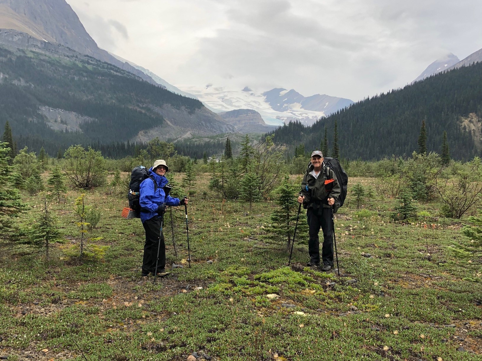
I know what you’re thinking – what would possess a guy in his late 60s to even think of attempting the toughest, wildest, most remote part of the Great Divide Trail? Especially after watching videos of thru-hikers struggling through the ordeal of impassable deadfalls and blowdowns, endless choking willow, and daunting fords?
Only one small thing really – the fact that I’d resolved to complete the entire GDT, come hell or high water (pun intended)!
So when I learned last spring that GDTA president Doug Borthwick was organizing a small group of members to do this hike in August 2022, I “invited” myself along without a second thought. Second thoughts came a little later when I saw the prices of all the ultralight equipment I’d need to replace all my old-school backpacking gear. Next came the realization that I’d actually never attempted a backpack trip of this length and difficulty – the closest being a 2-week trek of shorter distance over pristine National Park trails with two resupplies enroute – when I was a more sprightly 25-year-old.
On the plus side, this trip would follow a very active spring and summer, doing work trips on the GDT and hiking a section of the Appalachian Trail – so hopefully I’d be in good enough shape to allow a reasonable chance of success.
In the event, Doug decided this wasn’t the case for himself. He’d suffered a severe bout of Covid after the final work trip of the year on the High Rock Trail, and decided not to attempt the hike, opting instead to provide logistical support to our group and several other grateful hikers needing a lift to or from the end of the trail at Bastille Creek near Kakwa Lake.
August 13th found our hiking party of four bouncing and splashing over the final 30 or so kilometres of decommissioned forestry road in Doug’s sturdy pickup. A lone outbound figure came into view a short distance from the trailhead at Bastille Creek – it was none other than ‘Pez’ (Johannes Beiser) from Germany, whom we’d last encountered in early July just north of Coleman at the start of the High Rock Trail. Pez had the distinction of being the first GDT hiker over the new Allison Creek bridge and the new reroute built to access the bridge – which we’d just opened minutes before he arrived on the scene. It was great to renew acquaintances and hear about his adventures on his successful thru-hike.
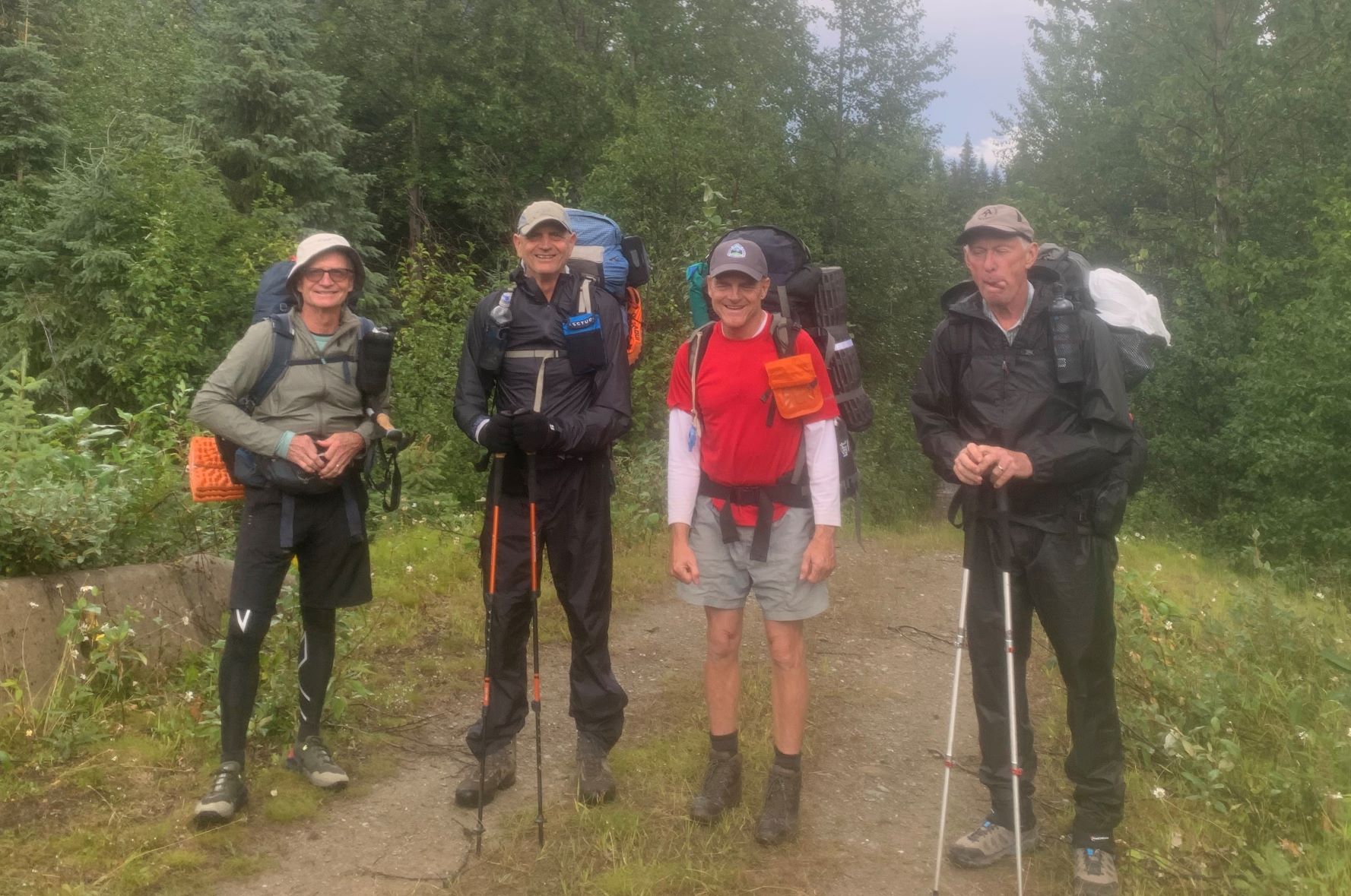
Then it was time to say goodbye and thanks a million and wish you were coming with us, etc., to Doug (who was eager to get turned around and give Pez a ride back to civilization). And so began a 15-day trek to where the GDT pops out on Highway 16 west of Jasper – a trail distance of 265 kilometres, or 280 including the out-and-back to access our resupply at the Blueberry trailhead. My hiking buddies were fellow GDTA volunteers Paul Jollymore, Stuart Mitchell, and Ernie Slatter – all in their 60s as well. Doug called us the 4 Musketeers.
A few words to describe the initial 28-km access to Kakwa Lake itself: it’s the bare minimum that must be traveled on foot (and that might soon double, as the BC Forest Service has stopped doing any maintenance on about 30 km of road to Bastille, possibly even pulling out several bridges on side-creeks rendering vehicle travel impossible). The route is a long-since abandoned section of the forestry road that’s reverted to trail status. Although used in winter by snowmobilers, it’s mostly single-track and includes one significant ford of Buchanan Creek at the 11-km mark (Note: a new footbridge was reportedly built here sometime after our trip, by persons unknown). Many areas are muddy and there’s a near-bushwhack alongside McGregor River where the old road has been washed away in places.
Arriving at the lake is something of a revelation, though, not least due to the pristine cabin that awaits hikers coming from both directions – kept that way in 2022 by park hosts Donna and Dan. That night we shared the place with David and Erika, an American couple that began their 2022 GDT trek at Mt. Shark near Canmore (profiled on their YouTube channel, Adventure Muffin Productions).
“The 4 Musketeers” at Bastille Creek – Paul, Ernie, Stuart and Dave (his expression indicating more second thoughts!!)
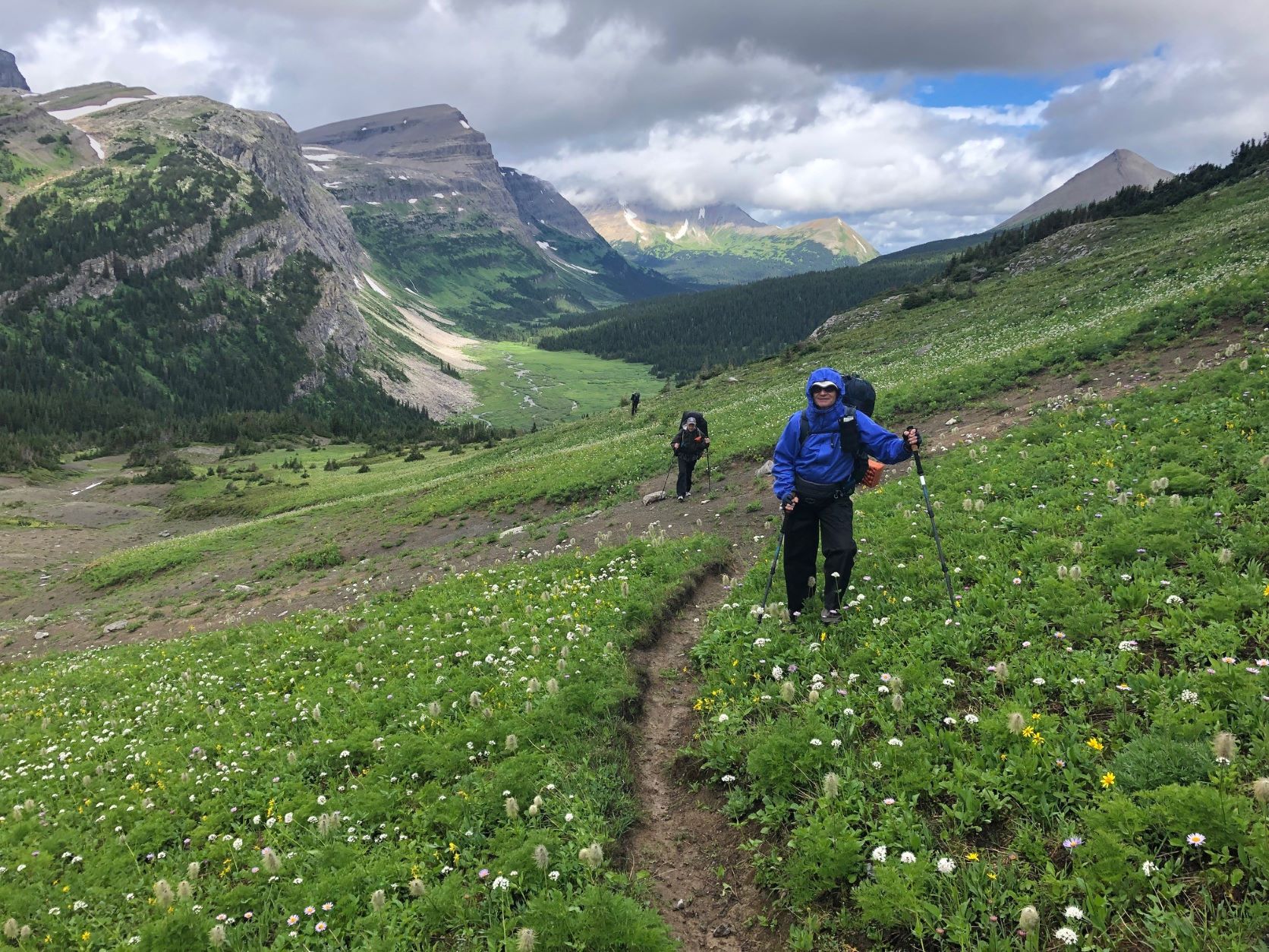
Willow-covered meadows at Providence Pass, looking south.
The next morning found us on the GDT proper at Kakwa River, just a short walk from the cabin, negotiating the first of dozens of creek and river fords we’d face over the next 2 weeks. Then it was literally a walk in the park as Dan had just brushed the willows for the first couple of kilometres of the extensive meadowlands the GDT route meanders through on its way towards Cecilia Lake, 15 km from the northern terminus. Reality hit after the manicured part, though – keeping to the trail became a team effort as one or two of us consulted the FarOut App and the others scanned the sparse tree cover for GDT reassurance markers or flagging tape. Short segments of actual but overgrown trail were interspersed with grassy meadows where we’d lose the route and have to fan out to find it again. This was to be the on-and-off pattern for the next couple of weeks. I sure missed my orange paint blazes! On the plus side, at low-elevation Providence Pass we caught sight of a majestic bull caribou which might have gone unnoticed if we had a trail tread to stare at the whole time.
Another not-so-great-for-hikers aspect of Section G is all the boggy, spongy, sodden terrain – it’s a feature of most valleys in this country, even where the land is sloped. The region seems to contain a sizable volume of Canada’s fresh water resources! And wherever tree cover is sparse, willow often takes full advantage, growing up to 2 metres high and making foot travel tiring and frustrating.
The size and extent of willow growth, and its tendency to fill any space where there’s enough water and sunlight, is staggering. We wondered whether all this willow was a more recent phenomenon, for surely it would have made horse travel very difficult if it was like this in earlier years. Some scientists claim that higher carbon levels in the atmosphere are encouraging leafy plants to thrive in places where growing conditions are otherwise marginal. Who knows – maybe there’s something to that. Any experts out there?
We’d already decided our trip would follow the official GDT route, avoiding the scenic alternates so we could get a sense of what this northern extremity of the GDT was really like and identify sections requiring maintenance or improvement. Needless to say we identified a lot!
Why did we do this trip southbound? Well partly for logistical reasons but also because we’d encounter the mostly NOBO thru-hikers face-to-face – find out where they’re from, hear their overall impressions of the GDT, and get first-hand trail reports. We met three that very first day, and many more in the following days.
That night’s camp objective was an alpine lake just south of Surprise Pass, about 22 km from Kakwa, but as the day wore on and route-finding consumed more and more time, that became more and more doubtful. A tricky ford of Cecilia Creek didn’t help the schedule, and neither did some serious willow-bashing between there and the Pass. We ended up 4 km short, finding a tolerable spot to make camp. The mosquitoes were atrocious and we hoped it was just that area, but alas they would be an attribute of every camp for the remainder of the trip!
What would not be repeated for the next week, however, was the rain that fell all that night and into the next morning – as luck would have it we were blessed with an awesome run of warm, crystal-clear days (apologies to Barb Lauer and her Section G hiking party, who did this route at the same time of year in 2020 and got rained on continuously – read all about it in the Autumn 2020 Pathfinder).
Paul on the way up to Surprise Pass, with upper Cecilia valley and Kakwa Provincial Park beyond.
Big Shale Hill – a mere 400 metre ascent (700 m for NOBOs!)
View of the Jackpine Valley from Big Shale Hill – eat your heart out, Barb!
For the next several days we followed the GDT through beautiful valleys and across high passes and ridges in a spectacular wilderness setting with a backdrop of glaciated peaks in every direction, while criss-crossing the continental divide multiple times. The 360-degree views from Big Shale Hill are not to be missed!
On the way down from the summit ridge, we encountered cleared trail for the first time since Kakwa Lake, 70 km back. This was the start of the amazing work done by the GDTA’s Jackpine trail crew in 2021 and ‘22, a much-appreciated contrast to the overgrown, deadfall-littered trails we’d been contending with to that point! From there on, we enjoyed a clear, easy-to-follow route throughout the Jackpine valley (with all 20 fords of the river!) and up to Blueberry Lake. Timing is everything, huh?
One of the 20 Jackpine River fords – rather enjoyable on a nice day!
A smiling Ernie cruisin’ along newly brushed trail in the Jackpine Valley.
A good example of willow cleared out by GDTA crews, with Stuart for scale.
Blueberry Lake is the junction of a 7.5-km access trail that descends almost 1000 metres to the Holmes River Forestry Road. At the exact midpoint of the trip, it was ideal for picking up provisions previously stored there for us – well, it would’ve been a lot more ideal if the trail wasn’t so rough and overgrown! But you gotta play the hand you’re dealt, and maybe we were just spoiled by then.
Leaving Blueberry, the Trail ascends quickly to the scenic highlight of the main route in Section G – a 3-kilometre alpine amble right on the Divide through rough, rocky terrain, with extensive views in all directions, including a tantalizing glimpse of towering Mt. Robson to the south. There’s no trail tread here, so cairns would be a welcome improvement to avoid having to constantly monitor the GPS track, draining precious battery capacity.
Beautiful Blueberry Lake – a very nice spot to camp for 2 nights.
Mount Robson seen in the centre distance from the Blueberry Alpine.
Soon the GDT enters Jasper National Park for the first time, at Bess Pass, after a steep descent from Bess Shoulder on a very rough bit of trail. At this point, about 150 km into the trip, it occurred to me that much of the GDT route from Kakwa uses old trails that don’t always follow the path of least resistance, i.e. along stream valleys and across passes. No, they often climb up and over difficult-to-reach high spots like Casket Shoulder, Big Shale Hill, Blueberry Alpine and Bess Shoulder. How did they get there? For that matter, how did any of the trails in the region get there? We surmised that most of them were created by and for guided hunting parties in the days before hiking became popular, when travel by horse was the most efficient way to get around – and, I suspect, big game could often be found in those upland locales.
Horse travel along what’s now the GDT is rare these days. We saw little evidence they were using the trail, although many low-elevation campsites obviously had annual visits by horses, probably in the fall hunting season.
Paul starting down from Bess Shoulder, with Chown Floodplain in the distance. Rough trail ahead!
Paul and Stuart pausing on the floodplain to admire Chown Glacier.
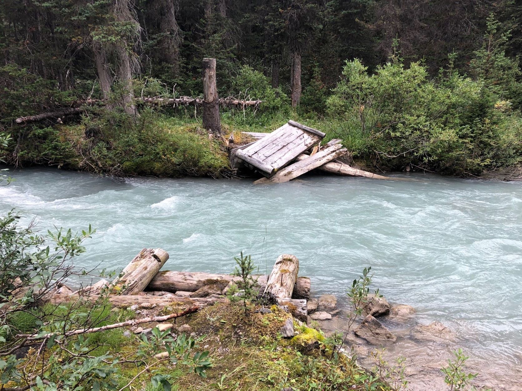
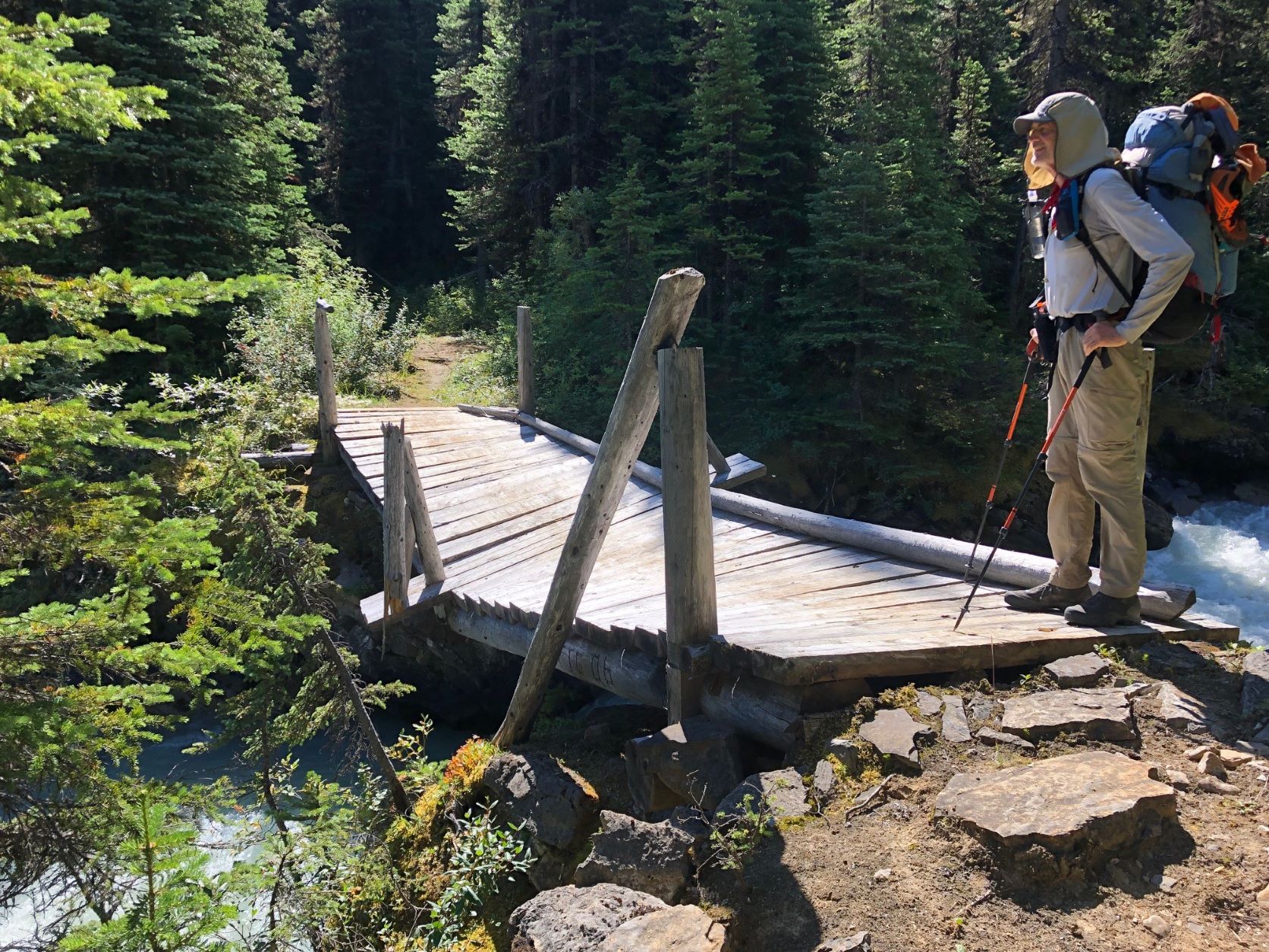
If we were expecting better trail conditions in the National Park, we were in for a disappointment. As I discovered later, all the trails used by the GDT north of Jasper have been officially deemed redundant, and no maintenance has been done for a number of years. Deadfalls and overgrowth abound, and of the many formerly bridged streams, only one still has a usable bridge and it’s not long for this world – check out the picture! When it’s gone, hikers will be in for a tough bushwhack and ford.
Remnants of Chown Creek Bridge – what happens when you give up doing maintenance.
Ernie at the only remaining bridge in Sections F and G.
The North Boundary Trail is a case in point. As someone who’s spent decades building and maintaining trails, exploring this one was a revelation. This GDT segment of the much longer NBT, along the Smoky River, was obviously constructed by skilled people who located, cleared and built a trail that would stand up to the passage of time and thousands of pack animals without degrading. Ernie told me this trail was in use as the main access to Mount Robson from Grande Cache before the highway was constructed through Yellowhead Pass, and possibly pre-dates the railway as well. It’s truly a thing to behold – cleared to 3-4 metres of width, gentle grades, and places where rock retaining walls were built up to support the trail on steeper ground. Sturdy, wide bridges were created using local timber and renewed periodically.
And sadly, this piece of Canadian heritage is being allowed to degrade and pass into history. Hopefully the GDT will be its saviour, but this won’t happen unless our organization is successful in convincing the “powers that be” that their current backcountry trails policy should be revised, for the sake of safety if nothing else.
North Boundary Trail – a master work of trail engineering and a treat to hike.
Strolling south through marvelous Moose Pass on the way into Mt. Robson Provincial Park.
After a long day’s travel along the North Boundary Trail, the GDT fords the Smoky and ascends to drop-dead-gorgeous Moose Pass, savouring the alpine for a few breathtaking kilometres as it gradually descends into Mount Robson Provincial Park. The trail is slightly better here, owing to BC Parks’ policy of allowing organizations like the GDTA to work with approved partners (in this case the Backcountry Horsemen of BC). The upper Moose River valley wasn’t overly hard to navigate but things improved dramatically after fording Upright Creek, and we followed just-cleared trail all the way to our campsite at Colonel Pass. A big shout-out to the GDTA crew and the aforementioned equestrian group! What did I say about timing?
Our second-last day, from Colonel Pass to Miette Lake, was enjoyable despite some blustery wet weather. The sweeping environs of Miette Pass (AKA Centre Pass) are a thing to behold, although the best wildflowers would have been seen a month earlier. A 3-km section of GDT once again has no trail to follow, but it’s pretty hard to get lost southbound. NOBO hikers, however, need to find one specific bit of orange flagging to locate the trail at the end of the tread-less segment.
Then, on our final day, we started down the Miette River Trail. Once again I was super-impressed with the quality of construction and the work that went into building this trail. Certain boggy areas along its 20-km length have, or should I say HAD, sturdy well-constructed boardwalks. About half the route is high above the river, in the forest, on a very steep slope. Long ago it was cut by hand into the hillside by people who were evidently obsessed with doing things properly – the trail keeps to a perfect, gently descending contour despite changes in the terrain, like gullies, and the need to remove large trees in the way. We don’t go to that much trouble building new trail these days (nor, I suppose, would we want to).
Sadly (again), this trail is being left to revert to a natural, or as Parks Canada puts it, a “wildland” state. Which is to say it will eventually become unusable. Ostensibly, Miette and the North Boundary Trail don’t get enough use to justify the expense of maintaining them, but that argument wouldn’t explain why Parks workers have been dismantling sections of boardwalk still in perfectly serviceable condition. More likely, current policy serves to discourage human use of the backcountry outside of specific areas that receive a lot of use, like the Skyline Trail for example. Just my opinion!
Still-intact Miette River Trail boardwalk – what a treat after all those bogs!
The author attacking “leaners” with the folding saw – what happens when you have a trail work addiction!
One “luxury” item I stuck in my pack at the last minute before leaving home was a small folding Corona saw. That turned out to be an inspired decision – not only was it super-useful for cutting firewood in camp, but having it on hand meant there was no excuse for not clearing the innumerable small-diameter “leaners” and “sweepers” that blocked the trail like railway crossing gates. Getting under, over or around these things is awkward and annoying. It took less than a minute to take care of each one, and over the course of the trip we must have cut out a couple hundred of these suckers! I think the GDTA should add a saw like this to the recommended gear list. (Note: it’s unlawful to cut any vegetation in the National Parks, unless you’re riding a horse and need to – hey, maybe I’ll take a horse with me next time!)
FINAL THOUGHTS
I’d highly recommend hiking this amazing part of the GDT if you haven’t done it yet. Yes it’s tough going, but trail conditions are improving every year. If a thru-hike is your plan, what you’ll find remarkable is how the landscape changes from one end of the Trail to the other, even though you’re in the Canadian Rockies the whole way. While the southern end is characterized by drier, less spectacular (but still breathtaking) terrain that’s never far from signs of civilization, as you travel north the mountains become more impressive, the creeks and rivers become deeper and swifter, and glaciers become a common sight. But you’re usually still only a day or two’s hike from a road. Once you leave Highway 16 near Jasper, however, you’re in a true wilderness the rest of the way. Everywhere you look are big mountains clothed in imposing glaciers, with cascading streams and waterfalls tumbling down their slopes.
You might be reading this thinking “I wonder if I could do this part of the GDT?” As long as you’re in good shape and have a reasonable amount of backpacking experience, then I’d say go for it! Having at least one or two buddies is essential, as is doing the trip in late summer or early fall to avoid the highest water and the nastiest bugs. But unless you’re in superb condition, willing to hike from dawn till dusk, and able to put up with a lot of discomfort, then plan on averaging 15 to 25 km per day (ours was 18) and resupply at Blueberry (we camped for 2 nights at the junction, hiking down with empty packs). Many thru-hikers are able to make 30 to 40 per day, but they’re often doing all F and G without a resupply. Park Host Dan told us some hikers arrived at Kakwa with zero food left, and he served up fresh-caught trout on more than one occasion, including to one person who was vegan!
An important point: The 2021/22 trail maintenance done in these sections has made a huge difference. And in mid-August 2023 the GDTA plans to clear and mark 28 km of poor trail between Sheep Creek and Kakwa Lake, and bridge the tricky ford at Cecilia Creek. So there’s never been a better time!
Lack of easy access to the northern terminus of the GDT at Kakwa Lake will be the main limiting factor, I think, for a lot of people wanting to do this hike. Conceivably, hikers will need to allow 2 to 3 extra days to walk the approach route if the road gets decommissioned. Margaret Gmoser, who at age 77 is likely the oldest person to have hiked Section G, describes in the Autumn 2022 Pathfinder how she solved the problem by hiring a helicopter to deposit her party at Kakwa. That might be a good option if the cost can be shared with a few others.
I’m extremely thankful to have had the opportunity (and the ability!) to cross Sections F and G off my to-do list. And it was also great to have three awesome guys to share the experience with. Now for Section E!!!
by Brent Wray; photos by Brent Wray; videos by Peter van der Gugten
I’ll never forget the text message that changed my life. It was from Curtis, a Willmore Wilderness guide and outfitter I’d ridden a 10-day pack trip with in July 2021.
“Hey Brent, that guy I was telling you about is riding the Great Divide Trail in 2022 and looking for company. You interested?”
It was now late October. I’d just finished checking out both the guy and the GDT online. The guy was Peter van der Gugten, a Swiss guide and adventurer, who travels the world doing epic, ultra-light long-rides on horseback.
“Hell, yeah!” I responded.
A few days later Peter interviewed me from Switzerland, via FB Messenger, asking about my riding and backcountry experience. I told him I’ve owned and ridden horses for years, successfully started a few colts, done a couple horseback treks, plenty of hiking and camping, but nothing of this magnitude. I’ve always wanted to, though! He said he’d discuss it with his riding partner and get back to me.
Three days later he contacted me and said, “Ok, you’re our #3. Welcome to the Adventure!”
Then began a serious baptism into route planning, researching trails, learning to use GPS, optimizing clothing and gear, acquiring permits and permissions and conditioning myself and my horse.
Route planning was interesting. I’d started with the standard backpacker route, but quickly found out there are many areas where horses aren’t permitted. Fortunately, an equestrian route is in development, which I was able to obtain, along with some great intel on certain sections that might be problematic.
Obtaining permits also proved interesting. National Parks require backcountry camp sites to be booked well in advance, as well as grazing permits. It is extremely challenging to know exactly where you’re going to be three weeks into a trail; trail conditions, bad weather, or a lame horse are just a few uncertainties making it a virtual impossibility. You do the best you can. Provincial Parks may also require letters of permission.
On August 22, we met for the first time at the Waterton Park gates with huge smiles, big hugs and tremendous excitement about our upcoming adventure. Tina Boche was the other member of our party; a long-rider in her own right, she owns a horse academy in Germany where she trains horses, mules and people, teaching riding, packing and driving. We consolidated gear and horses into my truck and trailer, then drove to Grande Cache the next day. One more day of preparations and we hit the trail August 25.
We travelled ultra-light, with saddle horses only. To make it easier for the horses, we dismounted and walked all steep terrain or tough, technical stretches, stopping every 2-3 hours to allow the horses a grazing break. At night horses wore a mixture of hobbles, bells and tracking collar, and were contained in portable electric fence on the best grass we could find. For us, on clear nights, we’d sleep under the stars; but most nights we’d sleep side-by-side, sardine style under a tarp shelter. As for meals: breakfast consisted of coffee and oatmeal; lunches: meat, cheese, nuts, dried fruit and water; dinner was Mountain House dehydrated backpacker meals fortified with extra protein, along with tea to drink.
A second Peter, Peter G, would be driving my truck and trailer as support and shuttle vehicle, meeting us in pre-planned, strategic locations and providing emergency support, if required. We communicated via Garmin InReach messaging. For navigation, we had redundant Garmin handheld GPS. We all carried Powerbanks for recharging electronics on the trail.
Leg 1
Leg 1 of our journey was Grande Cache to Jasper. Peter rode Rodeo, his Kentucky mustang; Tina rode Ahi, Peter’s Criollo from Argentina; and I rode Charlie, my Morgan from Alaska. All horses were shod with Duplo composite horseshoes. The trail was great and travelling easy for the first couple days, but our no-trail shortcut to connect to the Great Divide Trail from Ptarmigan Lake was a painfully slow bushwhack through thick brush, deadfall, bog, rough terrain and intermittent rain. After the better part of two days, we finally hit the GDT. Nothing makes you appreciate a trail like two days without one. Gratitude!
We were very grateful for the trail clearing efforts of volunteers from the Great Divide Trail Association and Back Country Horsemen of BC along the Jackpine River. It had consistently come up in my trail research as a long, nasty bushwhack through thick willows. Instead, we were treated to a wide, clear corridor that was almost a superhighway after what we’d been through.
After a steep grind up out of the Jackpine River valley, we were rewarded with epic views above Blueberry Lake, over Jackpine Pass, past Mount Bess and Chown Glacier. Weather steadily improved as we worked our way down the Smoky River, crossed spectacular Moose Pass and followed Moose River out to where our shuttle driver was waiting with the Adventure Rig. Longer than planned, tougher than anticipated, but we’d made it. Leg 1 was complete!
August 28, 2022
August 29, 2022
August 31, 2022
September 1, 2022
September 2, 2022
Leg 2
With all North-South routes through JNP closed to horses, our planned Leg 2 route was to start at the Cardinal Divide, onto South Boundary Trail, then through the Blackstone/Waipiabi Public Land Use Zone (PLUZ) to Saskatchewan Crossing. Tina’s horse, Ahi, had a sore front leg, so she stayed behind with Peter G while he recovered, so it was just Peter and I for this stretch.
All was going according to plan, until it came time to cross the Brazeau River into the Blackstone/Waipiabi. It was running way too high, fast and deep for us to cross at Dowling Ford, so we decided to stick to the South Boundary Trail, crossed the Brazeau further upstream, and over rugged Nigel Pass to the trailhead on Highway 93. Thanks to our Garmin InReach we were able to communicate the change in plan and meeting place to Tina and Peter G, our driver.
September 3, 2022
September 4, 2022
September 6, 2022
Leg 3
Leg 3 was from Saskatchewan Crossing to Banff. Ahi’s leg was still sore, so we got a loaner horse from Astoria Outfitting (Dixon) and Tina rejoined us. Herd dynamics came into play and our two horses weren’t very welcoming to the newcomer, so after getting beat up by both of them and a zap from our portable electric fence on the first night, he decided to go home, resulting in an extra 28 km of unnecessary travel. Fortunately, we caught him, got back on the trail, enjoying great trail, then lost the trail, endured a nasty bushwhack, found the trail again and made our way into Banff National Park to great trail and amazing scenery, over Clearwater and Pipestone passes, eventually pulling out at Lake Louise.
September 9, 2022
September 10, 2022
September 11, 2022
September 12, 2022
September 13, 2022
Leg 4
Ahi was recovered, so our driver took our loaner horse back and after a rest day we embarked on Leg 4 of our journey, Banff to Coleman. The horses must’ve really enjoyed their time off, because after grazing peacefully and lulling us into a false sense of security, they headed back to the trailhead on the first evening. It was many kilometers later and the wee hours of the cold, rainy morning before we caught them and got back to camp. They’d usually been hobbled when turned loose to graze, but they’d been so good we’d allowed extra freedom. So much for their rest day in Banff; no good deed goes unpunished, I guess. Hobble-free privileges lost.
Up, over Allenby Pass the next morning, we left BNP at Palliser Pass, crossing into Height of the Rockies Provincial Park, where we traversed three rock slides along Joffre Creek, endured a grinding climb over Sylvan Pass and then got our butts kicked as we worked our way through an old burn on the Middle Fork of the White River. At Connor Lakes, we decided we’d call it quits the next day in the Elk Valley. Tired horses, another mountain pass to cross and bad weather in the forecast, it was the right call to make.
September 17, 2022
September 18, 2022
September 19, 2022
September 20, 2022
September 21, 2022
Epilogue
So, after four weeks on the trail, covering 750km, we loaded up and went back to Waterton. All in all, an epic adventure, tremendous new friendships, a world of new opportunities and a whole new level of appreciation for a great mountain trail horse.
September 24, 2022
Needless to say, a trip like this doesn’t happen without the support of an amazing group of people. We are incredibly grateful for all those who supported us with their time, energy, skills, homes and knowledge: Tania, Caro (Duplo Canada), Frederic, Christine, Curtis and Melanie (Indian Trail Adventures), Rocky (Entrance Ranch), Gunner (Astoria Outfitting), Sean and Steve (Banff National Park), Kerry, Eric, Guy and Deb, Jenika and Ashleigh (Alpine Stables) and of course, spouses, family and friends who held the fort at home.
And here is the detailed story embedded in this two-part video series. Enjoy!